
The item illustrated and described below is sold, but we
have another example in stock. To view the example which
is currently being offered for sale, click the
"View Details" button below.


|
||

|

|
|

|
Stock# 61373
Description
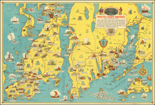
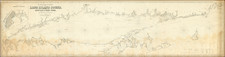
Scarce pictorial map of Mount Hope Bridge and vicinity, published in Bristol, Rhode Island by the Mount Hope Bridge Corporation.
The map is "Arranged" by John W. Haley, Rhode Island Historian, designed by H.W. Hetherington and lithographed by the J.C. Hall Company of Providence, Rhode Island.
The map extends from Newport and Prudence Island in the west to Martha's Vineyard, Falmouth and Buzzard's Bay in the east.
Includes vignettes showing historical items and points of interest.
This 1939 edition includes the map of Newport "Newport's Famous Ten Mile Drive Along the Ocean Front SHowing the locations of the beautiful Summer residences of many prominent people".
![[Boston -- 4 Views From The Harbor]](https://storage.googleapis.com/raremaps/img/small/65118.jpg)
