|
||

|

|
|

|
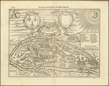
Rare separately published broadside illustrated the Siege of Poiters in 1569.
Detailed birds-eye view of the city of Poitiers, engraved to celebrate the resistance to the siege by the Huguenots led by Admiral Coligny. The long title tells how the city managed to resist thanks to "vigilance, prudence, value and virtue and ardor” of the Catholic commanders, of the governor Luda and of the inhabitants themselves.
The plan is oriented with west at the top, and illustrates in great detail the Huguenot attacking positions, camps, Bridges across the Clain River,
The plan is addressed to an Italian audience, expressing the importance of the "Italian Venturiers" Baglioni, Palavicino, Rangone and delegates of the Pope, Sforza, Orsini and Cesi.
The Siege of Poitiers
The siege of Poitiers (July 27 - September 7 1569) was a failed Huguenot attempt to capture the important trading center of Poitiers, under the command of Huguenot Admiral Gaspard II de Coligny.
1569 began with a Catholic victory at Jarmac in March 1569, a battle which saw the death of on of the primarily Hugonot commanders, the Prince of Condé. The Catholics next besieged Cognac, suffering heavy casualties. During the siege of Cognac, German Protestant reinforcements arrived.
The two factions fell back for a time, planning their next moves. The Huguenot Admiral Coligny wanted to attack Saumurto establish better lines of communication between La Rochelle and the Huguenots in the north, but the majority of the Huguenot leaders preferred to attack Poitiers, then one of the richest cities in France.
The Huguenot army marched to the city on July 24, 1569 and the siege began on July 27. The Comte de Lude let the defense of Poiters, joined by Henry, Duke of Guise and Charles, Duke of Mayenne.
Coligny focused on eastern side of Poiters, requiring his forces to cross the Clain River. Artillery fire managed to break a portion of the east wall, but the defense was able to destroy the bridge used to cross the river.
The defenders also managed to dam the Clain, causing flooding in the Huguenot campsite. The resulting lake flooded the Huguenot camp, and disease was rife. Even Coligny was taken ill.
In September, Coligny oved on the Rochereiul, at the southwest of Poiters. The town wall was breached and an assault was launched on September 3, 1569, but was repelled under the leadership of the Duke of Guise.
Reinforcements for Poiters, led by the Duke of Anjou, threaten the Huguenot-held city of Châtellerault, forcing Coligny to withdraw on September 7, 1569.
Antonio Lafreri (1512-1577) (also known as Antoine Lafréry and Antoine du Pérac Lafréry) was a French mapmaker, engraver, and publisher who worked in Italy. Lafreri was born in Franche-Comté and moved to Rome around 1540. Lafreri sold sheet maps but he also bound maps into books for his clients based on their interests and needs. These are the famous Lafreri atlases, important pre-cursors to the modern atlas. He also published well known works such as the Speculum Romanae Magnificentiae (ca. 1575), a collection of engraved views and images of Rome. Lafreri was well-connected to the cartographic networks of the time, collaborating with Giacomo Gastaldi, Battista Agnese, Antonio Salamanca, Donato Bertelli, Paolo Forlani, and others.

![(Seven Years' War) [Large contemporary British manuscript plan of the Bay and Battle of Quiberon]](https://storage.googleapis.com/raremaps/img/small/103273.jpg)
![[Perpignan]](https://storage.googleapis.com/raremaps/img/small/75063.jpg)