


|
||

|

|
|

|
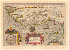
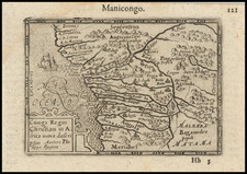
Gorgeous antique map of the West African Coast from Rio Senego (Senegal) to Cape Lopez, just below the equator, and includes Guinea with parts of Benin and Lybia. The map features a detailed inset of St. Thomas.
The map reflects the Portuguese exploration and mapping of the region. The map is one of six new maps of Africa to be included in Hondius' first edition of Mercator's Atlas.
Published by esteemed cartographer Jodocus Hondius in the first quarter of the 17th century, the map provides an indispensable record of the western coast of Africa, specifically focusing on the stretch of land and sea from the Senegal River and Gambia down to the islands of Fernando Po and São Principe.
The area depicted in the map had long been the focus of Portuguese exploration and trade. The Senegal River, reached by Portuguese navigator Nuno Tristão in the early 1440s, was one of the important milestones for Portuguese endeavors further south. By the late 15th and early 16th centuries, the Portuguese had solidified their presence by establishing trading posts along this stretch, including key locations such as Cacheu in modern-day Guinea-Bissau. Trade in this region was primarily concerned with gold, ivory, spices, and the slave trade, with the islands of São Tomé and Principe serving as key transshipment points for the latter.
In the early 17th century, when Hondius created "Guineae Nova Descriptio," the Portuguese were still the dominant European power in this region, although Dutch and English competition had begun to escalate. The map itself, therefore, serves as a somewhat retrospective account of Portuguese influence, capturing key ports, river systems, and geographical demarcations before Dutch maritime power began to seriously erode Portuguese hegemony in the area.
Jodocus Hondius the Elder (1563-1612), or Joost de Hondt, was one of the most prominent geographers and engravers of his time. His work did much to establish Amsterdam as the center of cartographic publishing in the seventeenth century. Born in Wakken but raised in Ghent, the young Jodocus worked as an engraver, instrument maker, and globe maker.
Hondius moved to London in 1584, fleeing religious persecution in Flanders. There, he worked for Richard Hakluyt and Edward Wright, among others. Hondius also engraved the globe gores for Emery Molyneux’s pair of globes in 1592; Wright plotted the coastlines. His engraving and nautical painting skills introduced him to an elite group of geographic knowledge seekers and producers, including the navigators Drake, Thomas Cavendish, and Walter Raleigh, as well as engravers like Theodor De Bry and Augustine Ryther. This network gave Hondius access to manuscript charts and descriptions which he then translated into engraved maps.
In 1593 Hondius returned to Amsterdam, where he lived for the rest of his life. Hondius worked in partnership with Cornelis Claesz, a publisher, and maintained his ties to contacts in Europe and England. For example, from 1605 to 1610, Hondius engraved the plates for John Speed’s Theatre of the Empire of Great Britaine.
One of Hondius’ most successful commercial ventures was the reprinting of Mercator’s atlas. When he acquired the Mercator plates, he added 36 maps, many engraved by him, and released the atlas under Mercator’s name, helping to solidify Mercator’s reputation posthumously. Hondius died in 1612, at only 48 years of age, after which time his son of the same name and another son, Henricus, took over the business, including the reissuing of the Mercator atlas. After 1633, Hondius the Elder’s son-in-law, Johannes Janssonius, was also listed as a co-publisher for the atlas.
![[West Coast Africa: Sierra Leone, Liberia and Guinea]](https://storage.googleapis.com/raremaps/img/small/40123.jpg)