|
||

|

|
|

|
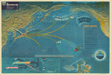
The Neptune Monograph, the definitive briefing book issued to senior American officers in preparation for the D-Day landings, with the famous two-sheet maps of Omaha and Utah Beaches.
In the lead-up to Operation Neptune, better known as the D-Day landings on the coast of Normandy, a flood of reports, maps, and coastal profiles were prepared for the Allied forces. Among the most comprehensive and detailed of these was the Neptune Monograph, which summarized Allied intelligence, with particular emphasis on the American sector including Omaha and Utah Beaches. Containing information of the highest sensitivity, it bore the distinctive “BIGOT” stamp, the highest level of military security classification, and it was printed and distributed in small numbers.
“An attempt was made to include in one convenient volume, in graphic form as far as practicable, a compendium of the intelligence required by ships and craft…. The Monograph was distributed to forces, groups, ships and craft down to LCT’s. Intelligence in the Monograph was kept up to date by the dissemination of supplementary intelligence to be inserted in the volume. This included corrections to material previously issued, and new intelligence based on photographic interpretations and revisions and additions to the plans for the operation.” (Commander in Chief, United States Fleet, “Memorandum: Report of NORMANDY INVASION,” Washington, Sept. 15, 1944. Accessed on line.)
The Monograph was issued under the authority of Rear Admiral Alan G. Kirk, Commander of Task Force 122, the huge fleet of landing craft and supporting vessels that that would deliver American forces to the beach. It is impossible to overstate the importance of Kirk’s role in Operation Neptune: The planning, preparation for and execution of the actual amphibious landings at Omaha and Utah Beaches were his direct responsibility.
Description and Contents of the Book
Small folio (13 x 8 inches). Spiral-bound with three original wire ties, original blue-green paper wrappers lettered: "TOP-SECRET | BIGOT" "REGISTER NO. 547" "NEPTUNE | MONOGRAPH" with a cartoon figure of Neptune striking the coast with his trident and carrying tanks ashore. 88 pages, and folios A - M (i.e., complete).
The Neptune Monograph reflects the collected intelligence available to American planners as of April 21, 1944. It is a treasure trove, combining strategic observations with tactical information, illustrated with a wealth of maps, charts, diagrams and photographs. The volume is divided into the following sections:
The book is divided into the following sections:
Section I: Weather, Sea and Surf (pages 7-12)
Section II: Tides, Currents and Astronomical Data (pages 13-25)
Section III: Terrain and Coast (pages 26-34)
Section IV: Beaches (pages 35-42)
Section V: Enemy Order of Battle and Capabilities (pages 43-50)
Section VI: Enemy Defenses and Installations (pages 51-68)
Section VII: Small Ports in Neptune Area (pages 69-84)
Section VIII: France Under German Control (pages 85-88)
Folios: Shoreline Sketches, Charts, Maps, Etc. (A - M)
The folios are as follows:
Folio A: Shoreline Sketch - Omaha Beach - East (Colleville-sur-Mer).
Folio B: Shoreline Sketch - Omaha Beach - West (Vierville-sur-Mer).
Folio C: Shoreline Sketch - Utah Beach - South (La Madeleine).
Folio D: Shoreline Sketch - Utah Beach - North (Ravenoville).
Folio E: Landing Craft Profiles - Omaha Beach.
Folio F: Landing Craft Profiles - Utah Beach.
Folio G: Vertical Mosaic - Omaha Beach.
Folio H: Vertical Mosaic - Utah Beach.
Folio I: Profiles of Lighter German Warships.
Folio J: Disposition of Known German Forces in France and Low Countries.
Folio K: Disposition of German Troops on Cherbourg Peninsula.
Folio L: Estimated Movement of Enemy Reserves.
Folio M: Coastal Sectors.
For map collectors and collections the maps of Omaha and Utah Beaches are of particular interest. Below the title of each map a brief note hints at the complex, multi-layered information-gathering effort required to produce them: “Map from GSGS 4490, sheets 79 & 80 and air photo examination.” Thus, they were the product of a multilayered effort: Starting with existing base maps and hydrographic data, largely supplied by the British Hydrographic Office, military cartographers and artists added data from aerial reconnaissance surveys by Allied warplanes, including extraordinarily dangerous low-level overflights. To these were added information from a host of other sources, including beach reconnaissance by Allied commandos (“frogmen”) and reports from French Resistance fighters.
The Neptune Monograph is simply bound with three wire rings, to facilitate the addition and/or replacement of material as new intelligence became available, plans were revised, and so on. Hence even its physical construction hints at what must have been an extremely fluid situation in the run-up to the invasion.
The BIGOT classification
The cover and many of the Folios bear prominently the unusual label, “TOP SECRET – BIGOT.” Introduced during the Second World War, BIGOT was the highest-level military security classification, above Top Secret. Some sources suggest that it was an acronym for “British Invasion of German Occupied Territory;” others, that it was a “backronym” for “To Gib,” the code stamped on the papers of officers headed to Gibralter in advance of the 1942 North Africa invasion.
Whatever the origins of the term, extraordinary efforts were made to protect BIGOT-level material. When for example a practice landing (“Operation Tiger”) on the Devon coast was ambushed by U-Boats, Eisenhower himself ordered the recovery of the bodies of the ten known victims with BIGOT clearance. This was necessary to prove that they had not been captured alive, as their capture would have compromised the invasion plans and necessitated its cancellation.
“But nothing was more secret—or more vital to Operation Neptune—than the mosaic of Allied intelligence reports that cartographers and artists transformed into the multihued and multilayered BIGOT maps.” (Thomas B. Allen, “Untold Stories of D-Day,” National Geographic Magazine, June 2002, vol. 201, no. 6, p. 15)
In all, a rare and richly-informative artifact from one of the most significant, dramatic and terrifying events in American military history.
Rarity and references
Not in OCLC or COPAC, though we are aware of copies at the National Archives (Kew, England) and the D-Day Story Museum in Portsmouth, as well as another in private hands.
Offered in partnership with Boston Rare Maps.

![[ British Colonies in North America & Caribbean ] L'Amerique Angloise, ou Description des Isles et Terres du Roi d'Angleterre dans l'Amerique, Avec de nouvelles Carte de chaque Isle & Terres](https://storage.googleapis.com/raremaps/img/small/102812.jpg)
![[Battle of Berlin] План г. Берлин 1:25000](https://storage.googleapis.com/raremaps/img/small/68524.jpg)