


|
||

|

|
|

|
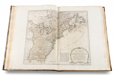
Gorgeous example of Morse's map of the Northern and Mid-Atlantic States. The map is most notable for the many land grants shown Western Territory, which then included Ohio, Tennessee and the Old Northwest Territory. The grants include Illinois Company, Army Lands, Wagbash Company, New Jersey Company, Ohio Company, and the 7 Ranges, along with the Donation Lands fro mthe Commonwealth of Virginia and General Clark's Grant 1500 acres. Many settlements are noted in the West, along with early forts Miami, Pitt, Venango, Chartres) and other interesting features. St. Louis appears on the map, as does Louisiville, St. Genevieve, New Madrid, St. Philips, Cahokir, and the Kaskaskais Village. A nice post-revolutionary war map of the region. This is without doubt the nicest example we have ever had, with unusually wide clean margins.
![(Civil War) Fredericksburg … [with] Map… of the Sioux Expedition [with] Map of the Fight of the 14th A.C. Buzzard Roost, GA [and ] Big Mound [and] Dead Buffalo Lake [and] Dry Fort Creek](https://storage.googleapis.com/raremaps/img/small/97072.jpg)
