|
||

|

|
|

|
Explorations in Western Canada
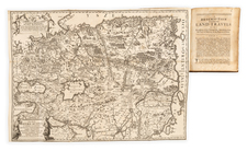
This set of maps accompanied the Report on the Exploration of the Country Between Lake Superior and The Red River Settlement, published by the Legislative Assembly of Canada in 1859. The set includes:
- The Route by Road & Navigation for Connecting the Atlantic and Pacific Oceans (25 x 10 inches)
- Profile of Route by the Grand Portage and Pigeon River from Lake Superior to Rainy Lake
- Plan Shewing the Region Explored by S. J. Dawson and his party between Fort William and the Great Saskatchewan River (80 x 44 inches)
The expedition, on which Dawson served as surveyor and naturalist, examined the route from Port Arthur on Lake Superior to Fort Garry (Winnipeg) and explored the country from Portage la Prairie to Lake Winnipeg, Lake Winnipegosis, the Saskatchewan River, Swan River and Fort Pelly, returning by way of Fort Ellice and the Assiniboine River.
Simon James Dawson was one of the first to attract attention to the suitability for colonization of the territory west of the Red River. His report includes discussion of the Hudson's Bay Company's establishments and the native tribes of the region.
![[ Mille Lacs Lake, Minnesota ] Thomas W. Allison Milaca, Minn. Reference: The Security State Bank Princeton, Minn.](https://storage.googleapis.com/raremaps/img/small/101935.jpg)
![(Chicago World's Fair & St. Paul, Minn.) [Contemporary album of 71 Photographs of St. Paul and Chicago World's Fair, Columbian Exposition]](https://storage.googleapis.com/raremaps/img/small/87334.jpg)
![(American Revolution) Geschichte der Revolution von Nord-America. Sammlung der besten Schriftsteller, welche die Geschichte, besondere Rechten, Sitten, und Gewohnheiten der Völker nach ihren Grundsätzen abgehandelt haben [with map:] Die Vereinigten Staaten von Nord=America. nach der Wm. Faden 1783. [History of the Revolution of North America. Collection of the Best Writers Who Have Discussed the History, Specific Laws, Customs, and Habits of the Peoples According to Their Principles [with map:] The United States of North America. According to Wm. Faden, 1783.]](https://storage.googleapis.com/raremaps/img/small/90124.jpg)
![Reize door de binnenlanden van Noord-Amerika, door Jonathan Carver . . . [with map:] Kaart van Capitein Carvers Reize in de binnenlanden van Noord-America in 1766 en 1767](https://storage.googleapis.com/raremaps/img/small/86685.jpg)