|
||

|

|
|

|
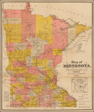
Striking full-color example of Rice & Bell's map of St. Paul.
Includes a marvelous early town plan of St. Paul, with indexes showing the street names and an index to the various additions to the original town plan of St. Paul. The dotted line shows the city limits. Wards are demarcated and labeled in red. A bridge across the Mississippi, several rail lines, ward boundaries, and other interesting details are also identified. The vignettes include Minne-Ha-Ha Falls, a railroad steam engine, paddle wheeler, the State Capital and allegorical farming scene. This is the earliest recorded map of St. Paul to appear in Philips. Rice would also publish an important early map of Hennepin County in 1873.
Some minor pencil notations on the map, updating an addition or two that apparently appeared after publication of the map.