|
||

|

|
|

|
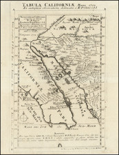
Antique Map of North America -- California as an Island
Old color example of Sanson's revised map of North America.
In 1705, Pierre Moullart Sanson radically revised this map of North America, modifying perhaps the three most significant features of Sanson's prior maps of North America.
The map radically re-casts the Mississippi River, adopting the model shown in pre-1700 manuscript maps by De L'Isle and the extremely rare first edition of De L'Isle's map of North America, which shows the Mississippi flowing into the Gulf of Mexico just north of the Rio Grande River, in modern day Texas. Only a few known examples of the first edition of De L'Isle's 1700 map of North America show this unusual river course, which dates to models of the Mississippi which De L'Isle was working with in manuscript form in the years before his first printed map of the region. The curious confluence of rivers near modern day New Orleans and the mouth of the Mississippi are no longer shown and in its place, a short lived northeasterly river is shown, more or less below the Ohio River. Most of the other rivers along the Gulf Coast have been eliminated.
The other significant change is the updating of the Great Lakes, reflecting an adaptation of the information from Coronelli and later 17th Century French sources. The west end of the lakes are now closed, unlike earlier editions.
![(Panoramic photograph) Camp Travis, Tex. 9/8/1918 East Side [WWI Camp Travis, near San Antonio, Texas, African American Troops]](https://storage.googleapis.com/raremaps/img/small/87312.jpg)