


|
||

|

|
|

|
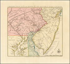
Rare French Map of the The Chesapeake & Ohio Canal
Rare map showing the region between Washington, D.C. and Pittsburgh, published by Guillaume Tell Poussin, one of the engineers who worked on the design of the Chesapeake & Ohio Canal.
The Chesapeake & Ohio Canal
After the Revolutionary War, George Washington was the chief advocate of using waterways to connect the Eastern Seaboard to the Great Lakes and the Ohio River. In 1785, Washington founded the Potowmack Company to improve the navigability of the Potomac River. His company built five skirting canals around the major falls: Little Falls (later incorporated in the C&O Canal), Great Falls in Virginia, Seneca Falls (opposite Violette's lock), Payne's Falls of the Shenendoah, and House's Falls near Harpers Ferry. These canals allowed an easy downstream float; upstream journeys, propelled by pole, were harder.
With time, the Erie Canal, completed in 1825, threatened traders south of New York City, who began to seek their own transportation infrastructure to link the burgeoning areas west of the Appalachian Mountains to mid-Atlantic markets and ports. As early as 1820, plans were being laid for a canal to link the Ohio River and Chesapeake Bay.
In early March 1825, President James Monroe signed the bill chartering the construction of the C&O Canal as one of the last acts of his presidency. The plan was to build it in two sections, the eastern section from the tidewater of Washington, D.C., to Cumberland, Maryland; and the western section over the Allegheny Mountains to the Ohio River or one of its tributaries. Free from taxation, the canal company was required to have 100 miles in use in five years, and to complete the canal in 12 years. The canal was engineered to have a 2 mph water current, supplying the canal and assisting mules pulling boats downstream.
In October 23, 1826, the engineers submitted the study, presenting the proposed canal route in three sections. The eastern section comprised Georgetown to Cumberland; the middle section, Cumberland, going up Wills Creek to Hyndman then across the Sand Patch Grade crossing the Eastern Continental Divide to Garrett, to the confluence of the Casselman River and the Youghiogheny River; and the western section from there to Pittsburgh.
In 1824, the holdings of the "Patowmack Company" were ceded to the Chesapeake and Ohio Company. By 1825, the Canal Company was authorized by an act of the General Assembly of Maryland, in the amount of subscriptions of $500,000, authorized by the act of incorporation, which paved the way for future investments and loans. The Chesapeake and Ohio Canal Company was formally organized in June 1828.
The C&O's first chief engineer was Benjamin Wright, formerly chief engineer of the Erie Canal. A groundbreaking ceremony was held on July 4, 1828. At the groundbreaking, there was still argument over the eastern end of the canal. The directors thought that Little Falls (at the downstream end of the Patowmack Little Falls Skirting Canal) was sufficient since that literally fulfilled the charter's condition of reaching the tidewater, but people in Washington wanted it to end in Washington, connecting to the Tiber Creek and Anacostia river. For that reason, the canal originally opened from Little Falls to Seneca, and the next year, was extended down to Georgetown.
In November 1830, the canal opened from Little Falls to Seneca. The Georgetown section opened the following year.
Guillaume Tell Poussin
Guillaume Tell Poussin was born in 1796 in the department of the Seine and Oise, in France. His father was a painter of some celebrity, who has left many fine works in the galleries of Versailles and Rouen. Introduced, while a child, to the favor of Napoleon, it was ordered by a special decree that, as a descendant of the great Nicholas Poussin, whose works are among the chief glories of French art, William Tell Poussin should be educated at the imperial school of Rouen. In Rouen, Guillaume entered this national academy of engineering.
In 1815, Guillaume travelled to America, arriving at New York in November, 1815. After a short residence in New-York he proceeded to Philadelphia and the next spring he moved to Washington, where he had heard that he could be profitably employed in the rebuilding of the capitol, which the British army had destroyed in the late war. He worked as an architect for about a year, when, several leading senators and representatives having become acquainted and signed a petition to President Madison for his admission to the corps of Topographical Engineers, which was then to be organized, and he was transferred to the United States Army. A short time after, General Bernard, whom Mr. Crawford, the American Minister at Paris, had engaged to be the chief of the Topographical Engineers, arrived in Washington, and assuming his office.
Poussin became aid-de Camp to General Bernard and left Washington with him for a military reconnaissance of the coast on the Gulf of Mexico, and of the delta of the Mississippi. They spent a year and a half in New Orleans and in 1817 returned to Washington and submitted to the President a memoir of their operations. It was upon this first report, presented by the Executive, on the Military Defenses of the United States,—a report drawn up in a very large degree by the hand of M. Poussin, and illustrated throughout with his discovery and suggestion,—that Congress, by an almost unanimous vote, authorized the erection of the great line of our military defenses, adopting the recommendations of the commissioner without even the slightest alteration.
The Board of Military Engineers entered subsequently on the yearly execution of their important duty of examining the coast previous to determining the actual sites and descriptions of the works of defense which they afterwards delineated. The young topographical engineer continued in his arduous scientific labors, and thus contributed largely in the perfecting of that great national scheme. It was in these military operations, and afterwards in the surveys for roads and canals, which, under the supervision of a Board of Internal Improvements, were confided to a portion of the same officers, assisted by civil engineers, that Poussin rendered himself so efficient as a practical and scientific surveyor, and became so perfectly familiar with all the internal resources of our extensive country, which he had thus most remarkable opportunities to study and appreciate, by crossing it in all directions, and, in fact, by visiting every state, and by following up and down every valley and river of the eastern half of the continent. Few men have had such occasion of studying visually the extent and resources of the republic; and the intelligent readers of the volume before us will acknowledge, that few persons have shown themselves more conversant with its astonishing advancement. His first publication was a description of the works to which he had contributed, under the title of " A History of the Internal Improvements of the United States his second, an account of all the railroads in this country, which had considerable influence in developing in Europe a disposition toward our policy in this respect, and entitles Major Poussin to the gratitude of all lovers of rapid and safe communication. It was reproduced in Belgium and Germany, and has long been a textbook upon its subject in those countries, as well as in France. His third work was the one now translated, La Puissance Americaine, in which he has displayed, most emphatically, his admiration of our institutions, and offered them as examples to communities aspiring after rational liberty. It may be said of it, that it is the American system rendered popular, by practical and convincing illustrations.
Major Poussin returned to France early in 1832. in the hope to cooperate in rendering popular in his own country some of the political institutions of the United States, to which he always attributed our great prosperity; but he was not fortunate enough to be admitted to active official life. He employed himself in his profession of surveyor, and superintended several important public works, and frequently in pamphlets and in contributions to the journals, labored for the dissemination of American ideas. At last, when the Revolution of February, 1848, broke out, he was chosen, with the greatest unanimity by the Provisional Government, to be the Representative of Republican France near the Government of the United States. It was deemed the highest compliment of which France was capable, that she sent as her minister the citizen most conversant with our affairs, and most eminent for admiration of our institutions. His arrival in this country, and the misunderstanding with the cabinet at Washington, which resulted in his recall by President Bonaparte, cannot have been forgotten by the observant reader. We believe that few who have carefully studied the conduct of Major Poussin in that affair, will be disposed, in the slightest degree, to censure him, while the entire history will readily be consigned to oblivion by the American who is in any degree sensitive upon the subject of our national honor.
Rarity
The map is scarce on the market.
![[Revolutionary War Plans of New York, Boston, Charleston, Delaware River to Philadelphia & Havana] Various Plans and Draughts of Cities, Towns, Harbours &c . . .](https://storage.googleapis.com/raremaps/img/small/83450.jpg)
![(Coast of Florida, Georgia and the Carolinas] [To The Members Of The Nautical Institution And Ship-Masters' Society Of The City Of New York, This Chart, Extending From Lat. 40°15 N., Long. 72°15 W., to Lat. 22°35 N., Long. 80°25 W., Is Respectfully Dedicated / By Their Obedient Servant Edmund M. Blunt]](https://storage.googleapis.com/raremaps/img/small/77294.jpg)


![Carte Particuliere de Virginie, Maryland, Pennsilvanie, La Nouvelle Jarsey. Orient et Occidentale [Heighten in Gold!]](https://storage.googleapis.com/raremaps/img/small/61392mp2.jpg)