This item has been sold, but you can enter your email address to be notified if another example becomes available.


|
||

|

|
|

|
Stock# 60789
Description
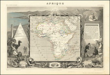
Interesting repurposing of a National Geographic map of Africa for use by the British military.
The map is characteristic of National Geographic's detailed and attractive color-printed maps, with additional labeling in the margins "FOR OFFICIAL USE ONLY OF THE BRITISH WAR OFFICE" and "Photolithographed by War Office, 1943".
The inset map at lower left illustrates air travel routes across the continent.
The coloring of the general map shows the colonial administrators: British, French, Italian, Belgian Congo, Portuguese, Spanish, and independent countries.
Condition Description
Folding map with some extraneous creasing and very minor wear. Manuscript highlighting (probably contemporary) of locations around Nigeria and to the south.
![[Fascist Organizations of Germany] Фашистские Организации Германии](https://storage.googleapis.com/raremaps/img/small/67801.jpg)