|
||

|

|
|

|
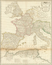
A modern copy of a portolan chart on vellum, decorated and illuminated. The work is based on a chart from the circle of Vesconte Maggiolo, the most important 16th-century cartographer from Genoa. The chart depicts Europe, North Africa, the Atlantic Ocean with the Canary Islands and the northern lands of Island, Sweden and Norway; the Red Sea is at the southeastern border and the coastal cities on the Mediterranean Sea are represented in great details. The chart is decorated with 8 compass roses, a Madonna with Child, 8 tents and 28 vignettes of the cities among which the grand cities of Venice and Genoa, each with its flag. This portolan chart is extremely similar to the one at the Beinecke Library at Yale University (Art Object 1980.156) but it presents some minor differences in the position of some of the borders and objects (some are moved by just a few mm and the place names are written in a different hand). The Yale chart is attributed to Vesconte Maggiolo although it is the only unsigned chart by the renowned cartographer.
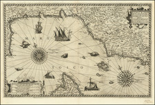
![[ Italian Mediterranean Coastline ] Hydrographica descriptio, in qua ore maritime Italiae a monte Argentato Napolim usque, promontoria item & portus, ajacentes insule...](https://storage.googleapis.com/raremaps/img/small/97984.jpg)