


|
||

|

|
|

|
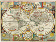
An English Rarity—Third State of Robert Walton's Rare, Decorative World Map
Striking example of Robert Walton's fine, separately-issued double hemisphere map of the world, which is often mistaken for John Speed's 1627 world map. However, while both maps are equals in their beauty and scope, the Walton is considerably rarer.
While the titles and geographic configurations of the Speed and Walton maps are quite similar, on close examination the maps have at least one significant difference which is readily observable. The positions of the allegorical figures are reversed, such that Fire and Aire are at the top of Walton's map, whereas they appear on the bottom of Speed's map. Speed's map is in turn based on William Grent's extremely rare map of the world published in London (1625).
The map bristles with interesting geographic details. The Strait of Anian separates North America from Asia in the far east of the eastern hemisphere. Japan is shown in a stout configuration, while Korea is shown as an island.
In the western hemisphere, California is also shown as an island. It is tucked into a massive western coast of North America which stretches diagonally to the northwest across the North Pacific. Another island of interest in this hemisphere is Frisland, the mythical island from the Zeno map, which is in the far North Atlantic.
Stretching across both hemispheres are coastlines which are suggestions of a massive southern continent. As a note in the southern Indian Ocean explains, “This South part of the world containing almost the third part of the Globe is yet unknowne certaine sea coasts excepted which rather shewe there is a land then descry either Land people or Comodities.”
The south land in the eastern hemisphere includes Beach and Maletur, which is a kingdom “abundant with sundry sortes of spices.” Both of these are toponyms from Marco Polo’s travels. Originally meant to denote regions of Java, they migrated south on early modern maps.
Farther west, another note mentions Psittacorum regio, “soe called of ye Portegals from ye extraordinary and almost incredible bignes of those birds there.” This place name appeared on Mercator’s 1541 globe and his 1569 world map. It was supposed to have been sighted by Portuguese sailors but was never verified in terms of size or location.
In the western hemisphere, Tierra del Fuego is ambiguously placed with relation to Statenlandt and the hypothetical southern continent. Here the continent is called Magellanica, “Ferdinand Magellanus gave name to this vast unknowne Tract from whom it is so called.” Nearby is a cartouche that proclaims the navigational prowess of Francis Drake and Thomas Cavendish, who both sailed around the world in the late-sixteenth century.
The central hemispheres are surrounded by smaller celestial hemispheres tucked at the center. Astronomy is further referenced with diagrams in the corners showing the Ptolemaic model of the solar system, a solar eclipse, a lunar eclipse, and an armillary sphere held by a disembodied arm and meant to show how to prove the sphericity of the earth.
Allegorical vignettes of Fire, Aire, Earth, and Water also adorn the map. Each is accompanied by animals, such as a salamander with Fire and an elephant with Earth.
The map includes portraits of four of the most famous explorers of the era: Francis Drake, Thomas Cavendish, Oliver Van Noort, and Ferdinand Magellan. Magellan’s crew completed the first circumnavigation of the earth in 1519-1522, although Magellan himself was killed in the Philippines. Drake and Cavendish completed the third and fifth circumnavigations on behalf of England in 1577-80 and 1586-8 respectively. Oliver van Noort was the first Dutchman to circle the world, and the ninth overall to do so, in 1598-1601.
States of the map and rarity
The first edition of Walton's map, engraved in 1656, included his name and address (Rose and Crowne) at the end of the title. Examples with Walton’s second address (Globe and Compass) are included with Thomas Porter’s A Compendious View…of the Whole World (1659).
This third state, with no maker information in the title, is sometimes attached to the English translation of the second part of Denis Petau’s History of the World (third edition, 1659). For this state, OCLC lists the examples at Yale’s Beinecke Library and the Ibero-Amerikanisches Institut Preußischer Kulturbesitz (Germany). There also several institutional examples included with Petau’s book.
Walton's map is much rarer than John Speed's map and is of equal artistic beauty and cartographic merit.
This strait, believed to separate northwestern America from northeastern Asia, was related to the centuries-long quest to find a Northwest Passage connecting the Atlantic Ocean to the Pacific. The rumor of this strait and a Northwest Passage in general inspired many voyages of discovery, including those of John Cabot, Sir Francis Drake, Gaspar Corte-Real, Jacques Cartier, and Sir Humphrey Gilbert.
The term Anian itself comes from Marco Polo’s thirteenth-century accounts of his travels. Polo used the term to refer to the Gulf of Tonkin, but cartographers thought it could refer to this supposed strait between Asia and North America. The Strait of Anian, so named, first appeared in a 1562 map by Giacomo Gastaldi, and was later adopted by Bolognini Zaltieri and Gerard Mercator.
The Zeno Map and the mythical island of Frisland
The Zeno family was part of the Venetian elite; indeed, their family had controlled the monopoly over transport between Venice and the Holy Land during the Crusades. Nicolo Zeno set off in 1380 to England and Flanders; other evidence seems to corroborate this part of the voyage. Then, his ship was caught in a huge storm, blowing him off course and depositing him in the far North Atlantic. He and his crew were wrecked on a foreign shore, the island of Frislanda (sometimes Friesland or Freeland).
Thankfully, the shipwrecked Venetians were found by King of Frisland, Zichmni, who also ruled Porlanda, an island just south of Frisland. Zichmni was on a crusade to conquer his neighbors and Nicolo was happy to help him strategize. Nicolo wrote to his brother, Antonio, encouraging him to join him and, good navigator that he was, Antonio sailed for Frisland and arrived to help his brothers. Together, they led military campaigns against Zichmni’s enemies for fourteen years.
Their fights led the brothers to the surrounding islands, presumably enabling them to make their famous map. Zichmni attempted to take Islanda but was rebuffed. Instead, he took the small islands to the east, which are labeled on this map. Zichmni built a fort on one of the islands, Bres, and he gave command of this stronghold to Nicolo. The latter did not stay long, instead sailing to Greenland, where he came upon St. Thomas, a monastery in Greenland with central heating. Nicolo then returned to Frisland, where he died four years later, never to return to Venice.
Antonio, however, was still alive. He ran into a group of fishermen while on Frisland. These fishermen had been on a 25-year sojourn to Estotiland. Supposedly, Estotiland was a great civilization and Latin-speaking, while nearby Drogeo, to the south, was full of cannibals and beasts. Antonio, on Zichmni’s orders, sought these new lands, only to discover Icaria instead. The Icarians were not amenable to invasion, however, and Antonio led his men north to Engroneland, to the north. Zichmni was enthralled with this new place and explored inland. Antonio, however, returned to Frisland, abandoning the King. From there, Antonio sailed for his native Venice, where he died around 1403.
News of the discoveries and the first version of the Zeno map was published in 1558 by another Nicolo Zeno, a descendent of the navigator brothers. Nicolo the Younger published letters he had found in his family holdings, one from Nicolo to Antonio and another from Antonio to their other brother, Carlo, who served with distinction in the Venetian Navy. They were published under the title Dello Scoprimento dell’isole Frislanda, Eslanda, Engrouelanda, Estotilanda, & Icaria, fatto sotto il Polo Artico, da due Fratelli Zeni (On the Discovery of the Island of Frisland, Eslanda, Engroenland, Estotiland & Icaria, made by two Zen Brothers under the Arctic Pole) (Venice: Francesco Marcolini, 1558).
At the time of publication, the account attracted little to no suspicion; it was no more and no less fantastic than most other voyage and travel accounts of the time. Girolamo Ruscelli published a version of the Zeno map in 1561, only three years after it appeared in Zeno’s original work. Ruscelli was a Venetian publisher who also released an Italian translation of Ptolemy. Ruscelli had moved to Venice in 1549, where he became a prominent editor of travel writings and geography.
Ruscelli was not the only geographer to integrate the Zeno map into his work. Mercator used the map as a source for his 1569 world map and his later map of the North Pole. Ortelius used the Zeno islands in his map of the North Atlantic. Ramusio included them in his Delle Navigationo (1583), as did Hakluyt in his Divers Voyages (1582) and Principal Navigations (1600), and Purchas (with some reservation) in his Pilgrimes (1625). Frisland appeared on regional maps of the North Atlantic until the eighteenth century.
In the nineteenth century, when geography was popular as both a hobby and a scholarly discipline, the Zeno account and map came under scrutiny. Most famously, Frederick W. Lucas questioned the validity of the voyage in The Annals of the Voyages of the Brothers Nicolo and Antonio Zeno in the North Atlantic (1898). Lucas accused Nicolo the Younger of making the map up, using islands found on other maps and simply scattering them across the North Atlantic. He also accused Nicolo of trying to fabricate a Venetian claim to the New World that superseded the Genoan Columbus’ voyage. Other research has revealed that, when he was supposed to be fighting for Zichmni, Nicolo was in the service of Venice in Greece in the 1390s. He is known to have drafted a will in 1400 and died—in Venice, not Frisland—in 1402.
Scholars still enjoy trying to assign the Zeno islands to real geographic features. For example, Frisland is thought to be part of Iceland, while Esland is supposed to be the Shetlands. Some still believe the Zenos to have sailed to these lands. Most, however, view the voyage and the map as a reminder of the folly and fancy (and fun) of early travel literature and cartography. Whatever the truth, the Zeno map and its islands are one of the most enduring mysteries in the history of cartography.
The popular misconception of California as an island can be found on European maps from the sixteenth through the eighteenth centuries. From its first portrayal on a printed map by Diego Gutiérrez, in 1562, California was shown as part of North America by mapmakers, including Gerardus Mercator and Abraham Ortelius. In the 1620s, however, it began to appear as an island in several sources. While most of these show the equivalent of the modern state of California separated from the continent, others, like a manuscript chart by Joao Teixeira Albernaz I (ca. 1632) now in the collection of the National Library of Brasil shows the entire western half of North Americas as an island.
The myth of California as an island was most likely the result of the travel account of Sebastian Vizcaino, who had been sent north up the shore of California in 1602. A Carmelite friar, Fray Antonio de la Ascensión, accompanied him. Ascension described the land as an island and around 1620 sketched maps to that effect. Normally, this information would have been reviewed and locked in the Spanish repository, the Casa de la Contratación. However, the manuscript maps were intercepted in the Atlantic by the Dutch, who took them to Amsterdam where they began to circulate. Ascensión also published descriptions of the insular geography in Juan Torquemada’s Monarquia Indiana (1613) (with the island details curtailed somewhat) and in his own Relación breve of ca. 1620.
The first known maps to show California as an island were on the title pages of Antonio de Herrera’s Descripción de las Indias Occidentales (1622) and Jacob le Maire's Spieghel Der Australische Navigatie (1622). Two early examples of larger maps are those by Abraham Goos (1624) and another by Henry Briggs, which was included in Samuel Purchas’ Hakluytus Posthumus or Purchas his Pilgrimes (1625). In addition to Briggs and Goos, prominent practitioners like Jan Jansson and Nicolas Sanson adopted the new island and the practice became commonplace. John Speed’s map (1626-7), based on Briggs’ work, is well known for being one of the first to depict an insular California.
The island of California became a fixture on mid- and late-seventeenth century maps. The island suggested possible links to the Northwest Passage, with rivers in the North American interior supposedly connecting to the sea between California and the mainland. Furthermore, Francis Drake had landed in northern California on his circumnavigation (1577-80) and an insular California suggested that Spanish power in the area could be questioned.
Not everyone was convinced, however. Father Eusebio Kino, after extensive travels in what is now California, Arizona, and northern Mexico concluded that the island was actually a peninsula and published a map refuting the claim (Paris, 1705). Another skeptic was Guillaume De L’Isle. In 1700, De L’Isle discussed “whether California is an Island or a part of the continent” with J. D. Cassini; the letter was published in 1715. After reviewing all the literature available to him in Paris, De L’Isle concluded that the evidence supporting an insular California was not trustworthy. He also cited more recent explorations by the Jesuits (including Kino) that disproved the island theory. Later, in his map of 1722 (Carte d’Amerique dressee pour l’usage du Roy), De L’Isle would abandon the island theory entirely.
Despite Kino’s and De L’Isle’s work, California as an island remained common on maps until the mid-eighteenth century. De L’Isle’s son-in-law, Philippe Buache, for example, remained an adherent of the island depiction for some time. Another believer was Herman Moll, who reported that California was unequivocally an island, for he had had sailors in his offices that claimed to have circumnavigated it. In the face of such skepticism, the King of Spain, Ferdinand VII, had to issue a decree in 1747 proclaiming California to be a peninsula connected to North America; the geographic chimera, no matter how appealing, was not to be suffered any longer, although a few final maps were printed with the lingering island.
The sequence of events and maps that led California to be portrayed as an island are much clearer than another famous peninsula-turned-island, Korea. Korea is briefly mentioned in the thirteenth century by Marco Polo as Cauli (Kauli), but otherwise Korea was not described again for European audiences until the late-sixteenth century.
As with Japan and China, most of the earliest bits of information about Korea came from the Jesuits sending letters sent back from East Asia. However, the Jesuits were not actually stationed in Korea; they could only glean impressions from Chinese and Japanese sources. For example, Father Luis Frois wrote of Korea in the context of a war with Japan in 1578. Frois explained that Korea was separated from Japan by a sliver of sea. It had previously been understood to be an island, he explained, but was now known to be a peninsula. However, why Korea was thought to be an island, by who, and how it was found to be a peninsula was not shared with Frois’ curious readers back in Europe.
The first known European to visit Korea was also a Jesuit, Father Gregorio des Cespedes. He accompanied Japanese troops during another war with Korea in 1592. The territory did not agree with Cespedes, who found it bitingly cold. He did not mention anything about the Korean peoples or their geography.
Travel writers, those who actually traveled and those who were more drawn to the armchair voyage, also wrote about Korea. Jan Huygen van Linschoten spent several years in Goa, India, where he had access to Spanish and Portuguese sources. In his Itinerario, first published in German and English in 1598, he suggests Korea is a large island called Core. Richard Hakluyt read the Jesuit letters, which were republished in sets of annual letters. In the second edition of his Principal Navigations (1599), Hakluyt included the information from Frois and Cespedes, scant as it was.
Given the relative dearth of source material, it is not surprising that early maps by Münster, Mercator and Ortelius omitted Korea entirely. The first map to show Korea was Orbis Terrarum Typus de Integro Multis in Locis Emendatus by Petrus Plancius (1594). It included “Corea” as a long, skinny peninsula barely attached to the northeast corner of China. Edward Wright, in the map accompanying Hakluyt’s Principal Navigations, adopted a similar depiction of Korea, as did other mapmakers from the 1590s onward.
Interestingly, the map that accompanied Linschoten’s Itinerario, by Arnold Floris van Langren, shows Korea as a large, round island. However, no other mapmaker is known to have followed this example. Another early island depiction that was widely adopted was that of Luis Teixeira in the 1595 edition of Ortelius’ Theatrum Orbis Terrarum. The long, thin island was used by several cartographers, including Jodocus Hondius, in the seventeenth century. Blaeu also used the Teixeira model before creating a new Korea in later maps that looked like a bat hanging from China, separated from the mainland by the thinnest of waterways.
Confusion over island vs. peninsula continued across seventeenth-century maps. For example, John Speed includes three separate versions of Korea across four maps in his A Prospect of the Most Famous Parts of the World (1626). It is shown on the Teixeira island model, as a thin peninsula, and as a blunt island. These various hypotheses as to the shape of Korea continued to coexist for decades.
Finally, in the 1650s, Father Martino Martini gathered more information and created a new map of Korea. In China from 1642 to 1651, Martini spent a good deal of time with Chinese maps and their makers. Thus, he created new maps showing Korea as a thicker, nearly rectangular peninsula in Bellum Tartaricum (1654) and the Atlas Sinensis (1655).
Also in the 1650s, a Dutch sailor named Hendrick Hamel was shipwrecked on Jeju, an island near southern Korea. Hamel and his fellow survivors would spend thirteen years in Korea, escaping to Nagasaki in 1666. He wrote about the ordeal in a journal that was published in 1668. Although it lacked maps, the ample descriptions confirmed that Korea gave a detailed, first-hand view of Korean geography and culture.
Nevertheless, several maps were published in the early eighteenth-century showing Korea as an island. The island myth, which most likely stemmed from a misreading of Japanese and Chinese maps by early Jesuits, proved to be quite entrenched. Only in 1735 did Jean Baptiste Bourguignon d’Anville produce a map with a roughly accurate outline of the peninsula and a relatively detailed interior.
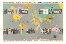
![(World) Des Mers On appelle mer cette vaste etendue… [Of the seas: We call sea the vast expanse of water that covers the larger portion of the earth. . .]](https://storage.googleapis.com/raremaps/img/small/91418.jpg)

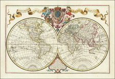
![[Illuminated World Map -- There is no region of the world which Jesus, like the sun, does not enrich...] Orbis nulla plaga est quam sol non ditet Iesus...](https://storage.googleapis.com/raremaps/img/small/62347.jpg)
![[English Edition!] Nova Totius Terrarum Orbis Geographica Ac Hydrographica Tabula Auct. Henr: Hondio. . . . 1630](https://storage.googleapis.com/raremaps/img/small/78002.jpg)