![[ Holy Roman Empire, Poland, Baltic, etc. ] Germania VI Nova Tabula (First state!) By Sebastian Munster](https://storage.googleapis.com/raremaps/img/small/94645.jpg)


|
||

|

|
|

|
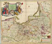
Excellent modern map of German Europe, with South oriented at the top of the map.
The map extends from the Baltic (Danzig, Kolberg, Rostok and Lubec) and Vistula to the Low Countries (Amsterdam, Rotterdam, Selandie Insulae, and Ghent) in the North to the Alps, Switzerland, Austria and Croatia (Sagabria, Geneva, Insbrug, Lucern, etc. shown) in the south. The map is centered on Nurnberg and the Franconia region and shows the extent of the Germanic regions of Europe in the 16th Century.
One of the best modern maps of the region to date. The map 1542 edition is unchanged from the 1540 edition. Munster's Geographia was a cartographic landmark, including not only Ptolemaic maps, but also a number of landmark modern maps, including the first separate maps of the 4 continents, the first map of England and the earliest obtainable map of Scandinavia.
Munster dominated cartographic publication during the mid-16th Century and is generally regarded as one of the most important map makers of the 16th Century. Munster was a linguist and mathematician, who initially taught Hebrew in Heidelberg. He issued his first mapping of Germany in 1529, after which he issued a call for geographical information about Germany to scholars throughout the country. The response was better than hoped for, and included substantial foreign material, which supplied him with up to date, if not necessarily accurate maps for the issuance of his Geographia in 1540.
A fine dark impression with wide margins.
Sebastian Münster (1488-1552) was a cosmographer and professor of Hebrew who taught at Tübingen, Heidelberg, and Basel. He settled in the latter in 1529 and died there, of plague, in 1552. Münster made himself the center of a large network of scholars from whom he obtained geographic descriptions, maps, and directions.
As a young man, Münster joined the Franciscan order, in which he became a priest. He then studied geography at Tübingen, graduating in 1518. He moved to Basel, where he published a Hebrew grammar, one of the first books in Hebrew published in Germany. In 1521 Münster moved again, to Heidelberg, where he continued to publish Hebrew texts and the first German-produced books in Aramaic. After converting to Protestantism in 1529, he took over the chair of Hebrew at Basel, where he published his main Hebrew work, a two-volume Old Testament with a Latin translation.
Münster published his first known map, a map of Germany, in 1525. Three years later, he released a treatise on sundials. In 1540, he published Geographia universalis vetus et nova, an updated edition of Ptolemy’s Geographia. In addition to the Ptolemaic maps, Münster added 21 modern maps. One of Münster’s innovations was to include one map for each continent, a concept that would influence Ortelius and other early atlas makers. The Geographia was reprinted in 1542, 1545, and 1552.
He is best known for his Cosmographia universalis, first published in 1544 and released in at least 35 editions by 1628. It was the first German-language description of the world and contained 471 woodcuts and 26 maps over six volumes. Many of the maps were taken from the Geographia and modified over time. The Cosmographia was widely used in the sixteenth and seventeenth centuries. The text, woodcuts, and maps all influenced geographical thought for generations.
![[Ancient and Modern German Empires] Carte de la Germany et les Diferents Etats ou ses Peuples ont Porte Leurs Conquestes](https://storage.googleapis.com/raremaps/img/small/78195.jpg)