|
||

|

|
|

|
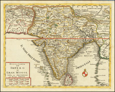
Arrowsmith's Colossal Map of India, The Largest Map of India Published Before the Great Trigonometrical Survey.
Excellent dissected example of Aaron Arrowsmith's extremely impressive nine-sheet map of India, published in London in 1816.
Arrowsmith's 1816 Improved Map of India was the greatest map of India published from information predating the Great Trigonometrical Survey (1802-1921). An 1876 catalog of maps of India elaborates the context of the map:
As these special maps accumulated the want of a new general map of India soon began to be felt, to supersede those of D'Anville and Rennell. In 1816, Aaron Arrowsmith published his Map of India in nine sheets, on a scale of sixteen miles to an inch, which was the last great general map based on route surveys. His subsequent Atlas of South India, published in 1822, was based upon the trigonometrical surveys of Colonel Lambton, filled in by the officers of the Madras Institute. (Maps of India, page 270)
Google Arts & Culture's Digitization of the Kalkriti Collection says of the large Arrowsmith India:
This gargantuan map occupies a special place in the history of the cartography of India, in that it is both a great technical achievement and a monumental object of profound political symbolism. Arrowsmith’s map is by far the largest, most accurate and most detailed general map of India made up to the time. It represents the apex of the Enlightenment Era Cartography of the subcontinent and is one of the finest maps of any subject produced during the early 19th Century...
Arrowsmith’s map is a composite of a vast variety of carefully selected antecedents, so numerous they cannot possibly be covered here. However, the most authoritative sources available to Arrowsmith were the road route surveys done by military surveyors, either as part of general civilian mapping commissioned by the EIC (such as James Rennell’s maps of Bengal, Bihar and Oudh) or surveys tracking military movement during campaigns. (Google Arts & Culture / Kalakriti Archives)
Arrowsmith illuminates some of his cartographic sources for the map in a dedication under the title of the map:
For the great additions and improvements in this republication of the Map of India I have to express my grateful thanks for the great assistance I have received _ To His Grace the Duke of Wellington for valuable Materials collected during his Campaign to India, To Col. Allan, Genl. Kyd. Sir John Malcolm, Sir James Mackintosh, Dr. Buchanan, Mr. Sydenham, but chiefly to the Honble. the Court of Directors for their liberally permitting me the use of the truly valuable Map of Mysore by Col. Colin Mackenzie Surveyor General of India.
Arrowsmith's large map of India followed his first separate map of India by 12 years and was a monumental production.
Provenance: Sothebys, October 20, 1992 (Sale 2942, Lot 844).
The Arrowsmiths were a cartographic dynasty which operated from the late-eighteenth century to the mid-nineteenth. The family business was founded by Aaron Arrowsmith (1750-1823), who was renowned for carefully prepared and meticulously updated maps, globes, and charts. He created many maps that covered multiple sheets and which were massive in total size. His spare yet exacting style was recognized around the world and mapmakers from other countries, especially the young country of the United States, sought his maps and charts as exemplars for their own work.
Aaron Arrowsmith was born in County Durham in 1750. He came to London for work around 1770, where he found employment as a surveyor for the city’s mapmakers. By 1790, he had set up his own shop which specialized in general charts. Arrowsmith had five premises in his career, most of which were located on or near Soho Square, a neighborhood the led him to rub shoulders with the likes of Joseph Banks, the naturalist, and Matthew Flinders, the hydrographer.
Through his business ties and employment at the Hydrographic Office, Arrowsmith made other important relationships with Alexander Dalrymple, the Hudson’s Bay Company, and others entities. In 1810 he became Hydrographer to the Prince of Wales and, in 1820, Hydrographer to the King.
Aaron Arrowsmith died in 1823, whereby the business and title of Hydrographer to the King passed to his sons, Aaron and Samuel, and, later, his nephew, John. Aaron Jr. (1802-1854) was a founder member of the Royal Geographical Society (RGS) and left the family business in 1832; instead, he enrolled at Oxford to study to become a minister. Samuel (1805-1839) joined Aaron as a partner in the business and they traded together until Aaron left for the ministry. Samuel died at age 34 in 1839; his brother presided over his funeral. The remaining stock and copper plates were bought at auction by John Arrowsmith, their cousin.
John (1790-1873) operated his own independent business after his uncle, Aaron Arrowsmith Sr., died. After 1839, John moved into the Soho premises of his uncle and cousins. John enjoyed considerable recognition in the geography and exploration community. Like Aaron Jr., John was a founder member of the RGS and would serve as its unofficial cartographer for 43 years. Several geographical features in Australia and Canada are named after him. He carried the title Hydrographer to Queen Victoria. He died in 1873 and the majority of his stock was eventually bought by Edward Stanford, who co-founded Stanford’s map shop, which is still open in Covent Garden, London today.
![(India) Decima Asie Tabula [Tenth Map of Asia]](https://storage.googleapis.com/raremaps/img/small/101340.jpg)