|
||

|

|
|

|
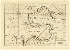
Detailed Map of the Isthmus of Darien and its Environs
Finely-detailed map of the Isthmus of Darien and the coast of South America. The map was part of one of the first histories of the island of Hispaniola, then split into Spanish controlled-Santo Domingo and French-controlled Saint Domingue.
The seemingly-fragile isthmus connecting North and South America is to the west, while the tip of South America is to the east. Cartagena, or Carthagene as is appears here, is the principal settlement shown to the east, while the forts of Porto Bello are listed to the west. A decorative cartouche in the upper center explains the title, maker, and date of production, April 1730.
The interior includes hills, lakes, rivers, and settlements, as well as information about indigenous peoples. Despite the presence of Europeans for two centuries by the time this map was made, portions of the depicted lands were still ‘peu connu’, or little known, as was the case with the Gulf of Darien.
This remoteness, paired with the resistance of the Darien people to Spanish invasion, made the coasts shown here prime territory for illicit acts. The Mosquito Coast, as it was known, was famous for illegal logging by buccaneers. Pirates also used the narrow strip of land. In the 1680s, a group of English marauders crossed the isthmus with the help of the Darien people, stole ships in the Pacific, and then raided Spanish shipping up and down the west coast of South America. The French had raided Cartagena as recently as 1697, while Porto Bello had also been attacked several times by the 1730s.
This map, although it carries no page number or binding instructions, was part of a book for which D’Anville produced several items. This was Father Pierre François Xavier de Charlevoix’s Histoire de L’Isle Espagnole ou de S. Domingue, the first volume of which was published in Paris in 1730. This was one of the first books to be dedicated to the history of the island and this map was part of an important source for the history and geography of the Caribbean region.
Jean-Baptiste Bourguignon d’Anville (1697-1782) was one of the foremost French geographers of the eighteenth century. He carried out rigorous research in order to create his maps, which greatly developed the technical proficiency of mapmaking during his lifetime. His style was also simpler and less ornate than that of many of his predecessors. It was widely adopted by his contemporaries and successors.
The son of a tailor, d’Anville showed cartographic prowess from a young age; his first map, of Ancient Greece, was published when he was only fifteen years old. By twenty-two, he was appointed as one of the King’s géographes ordinaire de roi. He tutored the young Louis XV while in the service to the Crown. However, royal appointment did not pay all the bills, so d’Anville also did some work for the Portuguese Crown from 1724. For example, he helped to fill out Dom João V’s library with geographical works and made maps showing Portugal’s African colonies.
D’Anville disapproved of merely copying features from other maps, preferring instead to return to the texts upon which those maps were based to make his own depictions. This led him to embrace blank spaces for unknown areas and to reject names which were not supported by other sources. He also amassed a large personal map library and created a network of sources that included Jesuits in China and savants in Brazil. D’Anville’s historical approach to cartography resulted in magnificently detailed, yet modern and academic, maps. For example, his 1743 map of Italy improved upon all previous maps and included a memoir laying out his research and innovations. The geographer also specialized in ancient historical geography.
In 1773, d’Anville was named premier géographe de roi. In 1780, he ceded his considerable library to the Ministry of Foreign Affairs to be used for as a reference library for diplomats. D’Anville is best known for several maps, including his map of China, first published in 1735, and then included with Du Halde’s history of that country (the Hague, 1737). His map of Africa (1749) was used well into the nineteenth century.
![[Hand Drawn Map] Le Golfe de Mexique avec les Pays Circonvoisins](https://storage.googleapis.com/raremaps/img/small/91580.jpg)