|
||

|

|
|

|
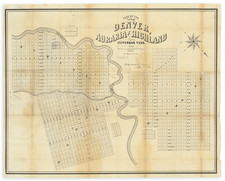
Stock# 60600
Description
Rare separately published map of the area around Idaho Springs, Colorado, as surveyed by James Underhill.
The map extends from Idaho Springs to Lamartine and Downieville and north to Central City, identifying the locations of hundreds of mining claims.
The map identifies the Tunnel Lines and Territory of the Big Five, which includes:
- The Central and Georgetown Tunnels
- The entire water power of the Clera Creek and the Belman Mine
- The Miami Mines and Wilcox Tunnel
- The Edgar Consolidated Mines
![Johnson's Nebraska, Dakota, Montana and Kansas [Rare Pre-Wyoming Territory configuration]](https://storage.googleapis.com/raremaps/img/small/94909.jpg)
![Indian Territory [with Colorado on verso]](https://storage.googleapis.com/raremaps/img/small/74706.jpg)