|
||

|

|
|

|
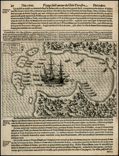
The Philippines, Australia and its Environs on Two Sheets of Arrowsmith’s Impressive and Massive Chart of the Pacific – From the First State to Include Flinders’ Investigator Voyage!
Two sheets from Aaron Arrowsmith's monumental nine-sheet chart of the Pacific, first published in 1798. The two sheets, from the 1814 state, cover the important recent discoveries in and around the Philippines and Australia, which was a busy port, penal colony, and haven for whalers and other traders.
These two sheets range north to south from the coast of China to the Philippines, the East Indies, and Australia. They include a portion of New Zealand in the far southeast, as well of Vanuatu, then known as the New Hebrides, and New Caledonia.
The sheets are in Arrowsmith’s characteristic detailed, yet elegantly simple, style, with only coastal outlines included. As a general chart intended to aid navigation, the chart also includes depth soundings and compass roses, which would help to plot a course for a ship when paired with more specific charts of particular places. Many detailed notes pepper the chart, offering a history of European exploration and colonization in the area dating to the sixteenth century. The tracks of ships also zig-zag the waters, marking the area as European in knowledge and largely erasing the presence of indigenous peoples.
Arrowsmith’s Sources
Arrowsmith’s sources are hinted to in the notes on the chart. For example, he references William Dampier on the west coast of Australia. Dampier’s books were bestsellers a century prior to the publication of Arrowsmith’s chart and his observations were still used by hydrographers thanks to his rare encounter with the west coast of New Holland.
Voyage accounts, and their accompanying charts, can also help to explain the many ship tracks that are printed on these sheets. They include the famous Pacific voyages from the 1760s, including Byron, Bougainville, Wallis, and the most famous of all, Cook. Later voyages are also included, such as Vancouver, Bligh, La Perouse, and others. Not all the tracks mark very famous ships. For example, one details the voyage of the Walpole to Canton in 1794. Captain Thomas Butler of the Walpole led a voyage round the Cape of Good Hope, then around the entirety of New Holland, to approach Canton from the east. Another lesser known vessel chronicled here is that of the Duff, a ship hired by the London Missionary Society to take their missionaries to South Seas islands in the 1790s.
To take the Philippines as an example, the famous Manila-Acapulco galleon track is marked, based in part on the chart and information made famous in Commodore George Anson’ Voyage round the World (1748). More recently, La Perouse’s doomed mission is marked as it sailed north just east of the northern Philippines in 1787. A year later, the Boussole and the Astrolabe would be wrecked on Vanikoro in the Santa Cruz Group, southeast of the Solomons. News of the wreck site would not be discovered until 1826, but La Perouse had sent back materials from his ports of call and, by the time this chart was originally published in 1798, his disappearance was still of great interest across Europe.
Besides English and French expeditions, Arrowsmith also references Spanish events, for example in a note just west of the Ladrones, or the Marianas. Around the Philippines, tracks show the Spanish voyages of Pedilla (1710) and D’Egui (1712), who both sailed to the Palau Islands in the early eighteenth century. This suggests that Arrowsmith had access to Spanish sources, some of which were usually kept secret from British eyes unless they could be stolen or captured at sea.
Such sources could be obtained through maritime contacts, but it is also known that Arrowsmith had special connections within the British charting body, the Hydrographic Office (HO), founded in 1795. Indeed, Arrowsmith worked for the HO from September 1795 to November 1796, where he saw the latest geographic sources from Royal Navy expeditions. He was also publishing charts privately at this time; his business was located on or near Soho Square from 1790.
Arrowsmith’s boss at the HO, Alexander Dalrymple, was loath to share his precious Royal Navy charts, logs, and journals with private mapmakers like Arrowsmith. However, the HO under Dalrymple was barely able to organize their existing charts, much less print new, accurate ones. Thus, a committee was formed in 1807 to review privately-published charts which were precise enough for naval use and also to identify areas where new charts were needed. Arrowsmith had reviewed by and familiar with the Chart Committee.
Dalrymple, unsurprisingly, disliked this committee oversight, particularly for the opportunities it granted to private publishers. Soon after the committee was formed, Dalrymple refused to give over manuscript charts of Australia that had been captured in 1795 showing the findings of the D’Entrecasteaux expedition to the Pacific. By 1807, the French nor the British, who had returned the originals to the French, had published the works, making charts of the region outdated. Dalrymple belatedly handed over his copies of the charts, but the episode illustrates how information could languish between manuscript and printed chart.
In 1798, based on sources he accessed through his ties at the HO, Arrowsmith published his first state of the “Chart of the Pacific Ocean.” It was approved by the HO’s Chart Committee for use by navigators in the Pacific region, one of very few charts to be so approved for that area. Arrowsmith continued to improve the chart by adding the latest discoveries up to 1832, the date of the last state of the chart.
The states of the Arrowsmith Pacific Chart
As a quick glance at these two sheets show, this chart could not have been published in 1798. The delineation of Australia in particular is too detailed, especially because Flinders, the first navigator to circumnavigate Australia, did not leave for this task in the Investigator until 1801. Other, more recent notes, also show that this is not a first state, but rather an updated state of Arrowsmith’s chart. These include the note, “The Ship Rolla found a westerly current of 16 miles pr. day from Mosquito Group to Tinian in November 1803.” Also, there are the Lord Auckland’s Isles, discovered in 1806; Hope Island, discovered 1807; and islands sighted by the Lady Barlow in 1809.
Arrowsmith’s chart were famous for their detail and, as the Pacific was being delineated at an accelerated pace after the 1760s, many new states of the chart were necessary to keep pace with geographic knowledge. In a 2012 article by Greg Wood, he lists the known states, although the list is based only on a search of Australian and British archives. The years of these states are 1798, ca. 1802, ca. 1805, 1808, 1810, 1814, 1820, and 1832. There are also likely several states published between 1820 and 1832.
Although the last date referenced on this edition is 1809, it is the detailed rendering of Australia that identified this as an 1814 state of the chart. It is in this state that Arrowsmith first included the findings of Matthew Flinders. These include Flinders’ charting and naming of the Australian coastline, particularly the southern coast, although Flinders’ track is not included. Additionally, the Gulf of Carpentaria has been reshaped as compared to earlier states.
This inclusion of Flinders in 1814 is important as it shows that, although the Admiralty already had Flinders’ charts and notes about his circumnavigation in 1805, Arrowsmith and the Admiralty did not preempt Flinders’ own publications of the information. Flinders was detained on his return to England at Mauritius, where he had been forced to stop due to the condition of his ship. Due to a continuing state of war with France, Flinders remained prisoner there from 1803 to 1810.
From October 1810 to July 1814, Flinders prepared and oversaw the publication of his papers and charts. The chart of Australia was published in January 1814, the voyage account and atlas in July. Flinders died on July 19, only the day after his atlas and account appeared. Arrowsmith released this updated state of this chart in December 1814.
Conclusion and Rarity
This chart is the most detailed chart of the Pacific to that date and is a marvel due to its size and features. These two sheets, those that show Australia, are arguably the most interesting for their changes over time.
Indeed, these sheets of the 1814 state are also part of the most important state, as they contain Flinders’ extraordinary charting of the Australian continent. The 1814 is also a scarce state of the chart, with complete editions known at the HO Archives in Taunton and the Peabody Essex Museum.
We note a single copy in a dealer catalog in the past 30 years (Shapero 2006; 1820 edition) and 2 copies at auction (Sothebys 2003-1801 edition; Sothebys 1992 (1820 edition)).
John Howell Books offered George Davidson's copy of the title sheet as a separate sheet in 1980 for $200). The Streeter copy of the map sold for $160 in 1968. Francis Edward Catalog 1014 offered the 1822 edition of the map in 1978 for 1200 GBP.
The Arrowsmiths were a cartographic dynasty which operated from the late-eighteenth century to the mid-nineteenth. The family business was founded by Aaron Arrowsmith (1750-1823), who was renowned for carefully prepared and meticulously updated maps, globes, and charts. He created many maps that covered multiple sheets and which were massive in total size. His spare yet exacting style was recognized around the world and mapmakers from other countries, especially the young country of the United States, sought his maps and charts as exemplars for their own work.
Aaron Arrowsmith was born in County Durham in 1750. He came to London for work around 1770, where he found employment as a surveyor for the city’s mapmakers. By 1790, he had set up his own shop which specialized in general charts. Arrowsmith had five premises in his career, most of which were located on or near Soho Square, a neighborhood the led him to rub shoulders with the likes of Joseph Banks, the naturalist, and Matthew Flinders, the hydrographer.
Through his business ties and employment at the Hydrographic Office, Arrowsmith made other important relationships with Alexander Dalrymple, the Hudson’s Bay Company, and others entities. In 1810 he became Hydrographer to the Prince of Wales and, in 1820, Hydrographer to the King.
Aaron Arrowsmith died in 1823, whereby the business and title of Hydrographer to the King passed to his sons, Aaron and Samuel, and, later, his nephew, John. Aaron Jr. (1802-1854) was a founder member of the Royal Geographical Society (RGS) and left the family business in 1832; instead, he enrolled at Oxford to study to become a minister. Samuel (1805-1839) joined Aaron as a partner in the business and they traded together until Aaron left for the ministry. Samuel died at age 34 in 1839; his brother presided over his funeral. The remaining stock and copper plates were bought at auction by John Arrowsmith, their cousin.
John (1790-1873) operated his own independent business after his uncle, Aaron Arrowsmith Sr., died. After 1839, John moved into the Soho premises of his uncle and cousins. John enjoyed considerable recognition in the geography and exploration community. Like Aaron Jr., John was a founder member of the RGS and would serve as its unofficial cartographer for 43 years. Several geographical features in Australia and Canada are named after him. He carried the title Hydrographer to Queen Victoria. He died in 1873 and the majority of his stock was eventually bought by Edward Stanford, who co-founded Stanford’s map shop, which is still open in Covent Garden, London today.
![Asie No. 110. Partie De Camboge [Vietnam]](https://storage.googleapis.com/raremaps/img/small/0206gh.jpg)

![S.E. Peninsula and Malaysia [Singapore inset and Pulo Penang or Price of Wales Island inset]](https://storage.googleapis.com/raremaps/img/small/103012.jpg)