|
||

|

|
|

|
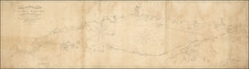
The Lands Surveyed by Samuel Harris, Robert Lettis Hooper and Samuel Wallis on the Great Bend of the Susquehanna River
Fascinating early manuscript survey map, showing a roughly 15 mile section of the Susquehanna River, where the river crosses into Pennsylvania from New York, including a meticulous depiction of the New York Boundary Line.
The map almost certainly reflects the surveying work of several important colonial frontier Pennyslvanian's, Samuel Harris, Robert Lettis Hooper and Samuel Wallis, drawn during the survey of a section of the Susquehanna River between October and December 1774. The map is also noteworthy for its inclusion of a number of early Indian settlements and Indian paths and for its treatment of the area around the future Harmony, Pennsylvania, an important early place in the Latter Day Saint History.
The map provides a detailed survey of the region, but does not identify any landowners, strongly suggesting that it was drawn some time prior to subdivision and granting of the lands in the are to Revolutionary War veterans, made after the American Revolution. The map shows:
- Apple Tree Town (also called Peach Orchard). This settlement was apparently destroyed on August 3, 1779, during General John Sullivan's Expedition against the Six Nations.
- Path To Delaware. This is the Great Bend Portage -- the 19 mile portage between the Susquehanna River the Delaware River -- See Adlum Wallis map of 1791.
- Path to Ononquago. This is a continuation of the Lackawanna Path to the Onaquaga Settlement, approximately 7 miles north, near Windsor New York.
- Old Tuschorora (Tuscarora) Town
- Old Indian Town (Lanesboro, PA)
- Indian House
- Old Indian House
- Accoreeco or Salt Lick Creek
- Seruhuck (Starucca) Creek
- Canawacta Creek
The map shows the northeast corner of Susquehanna County, Pennsylvania, including Great Bend Township and Oakland Township. The lands in question were sub-divided by 1784 and given to veterans of the American Revolution, most of which were warranted and surveyed in 1784 and 1785. A modern map of warranty lands is shown here: http://www.phmc.state.pa.us/bah/dam/rg/di/r17-522WarranteeTwpMaps/r017Map3081SusquehannaGreatBendWeb.pdf
Great Bend Portage
The map shows the Great Bend Portage. The Portage is described by Paul Wallace in Indian Paths of Pennsylvania (p. 139), as follows:
The Great Bend Portage ran from the Tuscarora Town at the mouth of Conawacta Creek (in the Great Bend of the Susquehanna at what is now Lanesboro) to Stockport on the Delaware River. On the Adlum-Wallis map entitled “A General View ... of Pennsylvania” (1793- 94), it is labeled “Portage 19ms.” and shown
as running between “Harmony” (Lanesboro) and Stockport.Samuel Harris’s draft of the Great Bend country, made in 1774, shows the path as running up the north bank of Conawacta Creek. Leaving the creek, it ran over the mountains by way ot Starrucca and Shehawkin Lake, and came down to the Delaware River at the mouth of Stockport Creek.
Probable Surveyor: Samuel Harris, October-December 1774
While the survey is unsigned, we think the most likely source of the map is the survey party led by Robert Lettis Hooper, which surveyed the Upper Susquehanna River in 1774, from which the above referenced "Samuel Harris draft" must have derived. We note existence of the following journal in the University of Notre Dame collection:
A manuscript journal kept by Pennsylvania native Samuel Harris from 14 October to 1 December 1774, recording the progress of a surveying party up the Susquehanna River.
Samuel Harris was the son of John Harris, whose ferry across the Susquehanna River would come to be known in 1733 as Harris' Ferry, later Harrisburg, Pennsylvania. The catalog entry for Samuel Harris's journal at Notre Dame states:
The journal is a stitched pamphlet (19 cm.) of 12 leaves, with 21 pages of entries in Harris's hand. The entries record the progress of a surveying expedition up the North Branch of the Susquehanna River, in present-day Bradford County, Pennsylvania. The journal commences on 14 October 1774, when Harris was below the confluence of Wyalusing Creek and the Susquehanna, and runs through 1 December, and the conclusion of the party's work. Entries appear for most days during that span; the typical entry is between 150 and 200 words. Much of the content consists of Harris's surveyor's field notes, but entries also include descriptions of the party's movements, observations on the land and weather, and one extended account (on 8 November) of a council with an unidentified Indian "King or Chief" concerned with the party's possible encroachment on Native land. The surveys recorded in the journal were made on lands lying along, and to the east of, the Susquehanna, immediately south of the "42 degree" (i.e., the New York line). The Iroquois had sold a sizeable portion of the area to Pennsylvania in 1768, but viewed the region north of the Chemung-Susquehanna confluence as the gateway to the lands of the Iroquois confederation.
The broader context of the expedition is not much alluded to in the manuscript. At the volume's conclusion Harris notes that "[T]he aforgoing Jornel and field notes are the work and Proceedings don for Robt Lettis Hoopper and Comp. by him". Hooper (c1730-1797) was probably the chief surveyor in the party; he had contracted to perform many surveys for Pennsylvania proprietors. Also involved with the expedition was Samuel Wallis (1730-1798), who had arrived in Lycoming County around the same time as Harris, and became known as the "Land King" for his tireless acquisition and speculation.
Accompanying the journal is an undated, unsigned record docketed "List of Proprietary Property of Sundry favourite grants." The relationship between this document and the journal is unclear. A typical entry notes the owner and location of a particular property in very general terms. The locations of the properties run across Pennsylvania from east ("Dr. ... 3000 included on old Indian Town on Delaware [River]) to west ("Alex'r McKee 500 at the mouth of Chartiers Creek 5 mile below Ft. Pitt"). Some areas listed in the document are also mentioned in Harris's journal, such as Lycoming Creek and Loyalsock.
Robert Lettis Hooper is known to have surveyed this region in 1774-75. As noted in the 1886 Report of the Regents' Boundary Commission Upon the New York and Pennsylvania (page 75);
The early surveys of the lands south of the Susquehanna River, in Broome and Tioga counties, were also based upon a temporary line partly run in 1774 or 1775, by Robert Lettis Hooper, upon which, at the west end adjoining the river, he laid out a British Military Land Warrant, which, with several tracts east of it laid out (upon paper) in 1786, were found in 1810, to encroach upon Pennsylvania lands. It is hardly probable that this line was identical with that shown upon George Palmer's map. It terminated on the left bank of the Susquehanna, at its western extremity, at "a Birch tree marked on two sides with three Notches a blaze above them," nearly a mile below the present boundary. At its eastern extremity at the middle intersection of the Susquehanna river, it was probably north of the present line.
Harmony / Joseph Smith
Of note, the map pre-dates the establishment of Harmony, Pennsylvania, which would become Harmony Township. The area which would become Harmony was first settled in 1789 when a road was built to connect Stockport on the Delaware River to the Susquehanna River at Cascade Creek. The town of Harmony appears on the Adlum-Wallis map of 1791 on the east side of the Susquehanna River, just south of the New York-Pennsylvania border. www.raremaps.com/gallery/detail/26788
Harmony, Pennsylvania, is an important historical site in Latter Day Saint history. Harmony is the place where Joseph Smith and Oliver Cowdery were visited by the angel of John the Baptist in 1829, where he bestowed on Smith and Cowdery the Aaronic priesthood. Smith and Cowdery subsequently baptized one another in the Susquehanna River.
Other significant events occurred there during the periodic residence of Smith from 1825 to 1830. Harmony was the home of Isaac Hale, father of Smith's wife, Emma Hale. Smith and his father boarded with Isaac Hale in 1825, while working on Josiah Stowell's mining project. In December 1827, Smith and Emma moved to Harmony from Manchester, New York, to work on the Book of Mormon. Eventually they bought a small farm and house, where most of the Book of Mormon was produced between April 7 and early June 1829.
The first convert baptism, that of Samuel H. Smith, took place there ten days after Smith and Cowdery had baptized each other. Somewhere between Harmony and Colesville, New York, Peter, James, and John bestowed upon Smith and Cowdery the Melchizedek priesthood. After the Church of Jesus Christ of Latter-Day Saints was organized by Smith in 1830, Smith and Emma returned to Harmony and lived there through that summer. Fifteen revelations now found in the Doctrine and Covenants were received in Harmony.
Ononquago (Ouaquaga) Settlement
Onaquaga (also spelled many other ways) was a large Iroquois village, located on both sides of the Susquehanna River near present-day Windsor, New York. During the American Revolutionary War, the Continental Army destroyed it and nearby Unadilla in October 1778 in retaliation for British and Iroquois attacks on frontier communities.
Onaquaga was home to members of the Oneida tribe, one of the Five Nations of the Iroquois Confederacy. The Iroquoian-speaking Tuscarora people joined in outlying settlements when they migrated north from South Carolina and became the Sixth Nation of the confederacy in 1722. In 1753, Nanticoke refugees from Virginia also moved into the village. That same year, Reverend Gideon Hawley established an Indian mission in the village. The establishment of the mission led to an increase in population of Christianized Indians living in and about the village, both those from the area and those who migrated from elsewhere.
Following the 1768 Treaty of Fort Stanwix, Mohawks were forced north and west and a number settled in Onaquaga, just west of the treaty line. By the time of the American Revolution, representatives from all of the Six Nations, a group of Algonquian-speaking Lenape people, and also a number of Loyalists lived in Onaquaga, a total population of about 400.
In 1778 during the Revolution, Joseph Brant used Onaquaga as a base for raids on New York and Pennsylvania frontier communities. In retaliation the Americans organized a raid commanded by Lieutenant Colonel William Butler. Faced with superior forces the inhabitants abandoned the town, which was then burned by the Americans.
The reference to the Ononquago Settlement is quite unusual.. We note only a single reference to the settlement and virtually no other references to just the name Ononquago. We located a reference to "A Map of the River Susquehanna in the Township of Chenango Comprehending the Ononquago Settlement, from Actual Survey made by James Cockburn for A. Hammond Esqr. A.D." 1788 in the Guide to the Draper Manuscripts (State Historical Society of Wisconsin) (Josephine Harper, 1983).
The most comprehensive explanation of the name appears in footnote in the 1820 book A Brief Topographical and Statistical Manual of the State of New-York at page 10, which notes:
. . . The spelling of Oghguage is believed also to be the most correct at this day. For although Lay's Map calls it Cookquago, and Spafford and Eddy write Oquago; yet I think the Indian characteristicks "gh: should no more be wholly omitted (as they vary not the pronunciation) than the regiment of letters we find in some authors should be retained. Judge Marshall writes Anoquagua, Gen. Washington, Ononguagua (a little confounded with Onondaga), and others Ononquago. Mr. Jefferson calls the tribe which gave it a name “Aughguaghas,” preserving the characteristicks "gh" throughout, with the French flu for O. The place, it would seem, should be called Oghqugho or “Oghquago,” as I have printed it. But Mr. Allen, in his American Biog. Dict speaks of “Onohoghgwage, or as it is sometimes written, Oughguaugha, on the Susquehannah river.” . . .
Samuel Harris was born May 4, 1733. His father, John Harris, Sr., operated a ferry across the Susquehanna River in south-central Pennsylvania, which would come to be known as "Harris's Ferry" (now Harrisburg).
Samuel Harris was an early settler of present-day Lycoming County, Pennsylvania; by the late 1760s he had moved up the West Branch of the Susquehanna, to the area of Loyalsock, were lived for many years, serrving as town assessor from 1796 to 1798.
He later moved further north to the Finger Lakes region of New York, settling at Cayuga Lake, where he died in 1825.
![[Jefferson's Notes on the State of Virginia] Observations sur la Virginie [with the map:] A Map of the country between Albemarle Sound, and Lake Erie, comprehending the whole of Virginia, Maryland, Delaware, and Pensylvania, with parts of several other of the United States of America. Engraved for the Notes on Virginia.](https://storage.googleapis.com/raremaps/img/small/51828.jpg)