


|
||

|

|
|

|
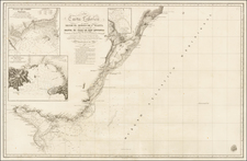
First Map of the Rio de la Plata Basin—Rare Map with Manuscript Additions & 3 Page Manuscript Suggesting A French Colonization Effort In The Region
Nice example of Grégoire Gaspard Félix Coffinières rare map of the Rio de la Plata Basin, the second largest fluvial system in the world. It was compiled by Coffinières during his time in Argentina in 1849 and 1850 and includes manuscript additions outlining an intriguing colonial project.
Coffiniere's map is accompanied by a 3 page hand written report extolling the virtues of Misiones, where the colonial project was located. The manuscript was apparently intended as part of a prospective French Colony in the region, which was under consideration in about 1855.
The map shows the entirety of the massive Rio de la Plata Basin, an area which includes part of what is today Argentina, Uruguay, Paraguay, and Brazil. It shows the principal tributaries of the basin, the Paraná, the Uruguay, and the Paraguay, and many other waterways are also shown. Great forests, particularly in Entre Rios, so-called because it is sandwiched between the Paraná and the Uruguay Rivers, cover large parts of the territory. A road network is traced as well.
There are several crossed swords on the map, accompanied by years in circles. These mark battles that took place as nations of South America fought for their independence, first from Spain and then from each other. Indeed, Argentina was still enduring civil war when this map was made. It would only become the nation state that we know as modern Argentina in 1861.
As the title in the lower right corner explains, the map was made by Grégoire Gaspard Félix Coffinières. He was a graduate of the prestigious École Polytechnique, then a military academy focused on engineering and the sciences. Coffinières was, therefore, a highly trained military engineer whose work was gathered from the latest documents he found while in the Rio de la Plata region, as well as other plans he gathered in Europe. The importance of this area is underlined by the fact that the map was engraved and published by the French Dépôt de la Guerre, or the War Department.
This is the first known map to focus exclusively on the Rio de la Plata Basin. River mapping was centuries old at the time this map was printed, but the focus on river basins was relatively new. In the eighteenth century, Philippe Buache created several maps of the world’s watersheds as a way to illustrate his theories of underwater mountain chains which in turn influenced the world’s river systems. This map is the earliest known example to focus so narrowly on the Rio de la Plata Basin.
The Aguapey Peninsula and Blaise Despouy
In addition to being extremely rare—OCLC lists six known copies—this particular example of the map contains manuscript additions and hand-coloring. The manuscript additions focus on one particular area, in the province of Missiones. Misiones, as it now known with the Spanish spelling, is today the northeastern most-province of Argentina. Before European invasion, it was long settled by indigenous peoples, including the Kaingang, the Xokleng, and the Guaraní.
In the seventeenth century, the Jesuits established many of their missions in a band that stretched from Paraguay to Misiones to Uruguay and Rio Grande do Sul in Brazil. These missions were largely abandoned by the 1770s, when the Jesuit order was suppressed. Despite Guaraní resistance, the economy shifted to a plantation economy and many Guaraní people were forced into slave conditions.
Throughout the early- and mid-nineteenth century, Paraguay, Uruguay, Brazil, and the United Provinces of Rio de la Plata (a forerunner to Argentina) fought over Misiones, a fertile agricultural area best known today for its magnificent waterfalls. Only in 1876 would Argentina officially gain control over the province.
When this map was made, then, Misiones was a contested territory, a status that offered opportunities to ambitious men caught up in war. This explains the yellow-colored section of the map, labeled "Péninsule de L’Aguapey appartenant à Bze Despouy," or the Aguapey Peninsula, which appertains to Bze. Despouy. It seems that somehow Monsieur Despouy obtained a sizeable chunk of the Misiones region, specifically the triangle of land formed by the Uruguay and Aguapey Rivers.
Bze Despouy refers to Blaise (or Blas) Despouy, whose life remains somewhat of a mystery. He was a Frenchman, one of nearly 5,000 in the area during this time. He became embroiled in the wars of independence and civil wars that wracked the region throughout this period and surviving correspondence in South American archives show that he was in touch with high-ranking military commanders of the Banda Oriental area. In the mid-1820s, Despouy traded a quantity of cotton, ponchos, handkerchiefs, hoes, axes, and horses to Félix Aguirre for the large portion of land here shown in yellow.
If little is known of Despouy, more is known of the person on the other side of the transactions, Félix Aguirre. Aguirre (1790-1834) was a Rio de la Plata soldier and politician. After fighting on behalf of Buenos Aires and its allies, in 1821 Aguirre became the governor of Misiones. The political situation was still fluid, and at times his position was only nominal, but Aguirre exercised power over Misiones for much of the 1820s. However, he was seldom in the province for long, as he was constantly on the move as a commander in the larger wars of independence and civil conflicts. The sale to Despouy was compensation for Despouy’s goods and supplies, which Aguirre needed to continue to fight.
Why, then, would this land deal struck in the thick of war matter thirty years later, when this map was made? It seems the Despouy never relinquished his claim on the land. In 1856, just after this detailed map of the region was published, it seems Despouy attempted to sell the land to a maritime company in France, perhaps in his native La Rochelle.
A French Colony in the Misiones?
This map may have been a planning document for the French businessmen and officials interested in a South American foothold. The present example is accompanied by a three-page explanation that suggests that colonization of the area by European immigrants was the goal. The unsigned description tells of how fertile the land is for animal husbandry and agriculture. The climate is considered safe for Europeans and the author even says that Misiones is known as the Italy of South America. Interestingly, a note in another hand has added that most of the villages in the region are in ruins, perhaps a reference to abandonment by the now long-gone Jesuits.
These grand plans came to naught, however. The news that the French intended to exercise a claim over Misiones understandably alarmed the Rio de la Plata officials, who used diplomatic channels to halt the attempt. The French ambassador surrendered the French claim to the holding in 1856.
In fact, this prospective colony was at the leading edge of the French wave of immigration in Argentina. From the second half of the nineteenth century to the first half of the twentieth century, Argentina received the second largest group of French immigrants worldwide; that largest group went to the United States. Argentina received 1,484 French immigrants in 1856. The number of French immigrants present in the province of Buenos Aires reached 25,000 by1859.
In 1857, an immigrant from Béarn, Alejo Peyret, founded the first farming colony very near to Misiones. The French colony was in San José, Entre Ríos. In 1864, out of 380 families living in two town, 125 were from Savoy. Eventually, French settlers would also build their lives in Misiones and would profoundly impact its culture and development.
Conclusion & Rarity
This map illustrates a little known and intriguing colonial episode from the most tumultuous period in the history of the Rio de la Plata. It is also extremely rare, with only six known copies: three in the USA, two in France, and one (damaged) in Australia as listed in OCLC. This first known map solely focused on the Rio de la Plata Basin tells many stories and would make a worthy addition to any collection of South America maps.
Grégoire Gaspard Félix Coffinières was a French general, best know as the commander of the École Polytechnique during the Second French Empire.
Grégoire Coffinières was the son of Alexandre Coffinières. In 1829 he passed the entry exam of the École polytechnique, where as a student he took part in the Three Glorious Days of the revolution of July 1830. After graduating in 1831, he became a combat engineer.
After serving time in Algeria, he returned to France in 1837. in 1844, he participated in an expedition to Morocco. In 1845, he was appointed to head a corps oof engineers at Auch.
Coffinières returned to Morocco in 1849, then then left for Argentina, where he created the first map of the La Plata Basin in 1850, drawing hte map from "documents collected in situ and the best partial plans of that region".
In 1855, he participated in the siege of Sevastopol and was promoted to Brigadier General. Coffinières succeeded General Charles Eblé in the command of the École polytechnique from 1860 to 1865. During the Franco-Prussian War, he served as superior commander of the fortifications of Metz.
Coffinières was captured and interned at Hamburg. Freed after the war, he left active duty in 1876 and retired in 1881. He died in 1887.
By imperial decree of November 2, 1864, Coffinières was authorized to add de Nordeck, a name from his family's maternal branch, to his last name. He was also Commander of the Legion of Honor.
![[ Bolivia ] Carte Commerciale de Bolivie Par F. Bianconi . . . .3e. Edition 1890](https://storage.googleapis.com/raremaps/img/small/101854.jpg)
![[ Rio de Janeiro ] Planta Informativa Do Centro Da Cidade Do Rio De Janeiro. Especialmente Organisada Para o Guia Briguiet Pelo Professor Arthur Duarte Ribeiro . . . 1932](https://storage.googleapis.com/raremaps/img/small/66693.jpg)
![Patagonia [with] South Orkney [with] Falkland Islands [with] South Georgia Island](https://storage.googleapis.com/raremaps/img/small/77042.jpg)