


|
||

|

|
|

|
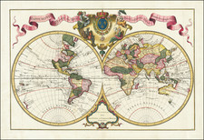
Fine World Map by Renowned Dutch Publishers Covens & Mortier
Nice double hemisphere map of the world, showing the tracks of the latest explorers to that date. It also reveals the partial state of knowledge about certain features, like Australia, which was still emerging for European mapmakers.
The hemispheres are projected on a plain background, marking a shift to less ornate world maps in the mid-eighteenth century. A delicate frame at the bottom explains that the map was published in Amsterdam. Between the hemispheres at the top is a coat of arms flanked by four women representing the continents of Africa, America, Asia, and Europe. A ribbon proclaims that this map was originally delineated by Guillaume Delisle, the respected French mapmaker.
The eastern hemisphere
Europe, Asia, and Africa are familiar in their outline, but the islands of Southeast Asia and the Pacific are emergent, reflecting the uncertain state of geographic knowledge about those areas by Europeans in the early-eighteenth century.
A conjectural coastline connects Carpentaria, in northeast Australia, to New Guinea. In reality, Luís Vaz de Torres, who sailed with Pedro Fernandes de Quiros in 1605, had passed through the straits between New Guinea and Australia. However, the Spanish had suppressed his report in the hopes of maintaining power via geographic secrecy and the Strait was only rediscovered by Alexander Dalrymple in 1762 when he was researching documents captured from the Spanish in the Philippines during the Seven Years’ War. Later, James Cook sailed through the Strait, confirming its existence to the Western world, during his first voyage.
The aforementioned Quiros, in turn, got his start in the Pacific under the command of Alvaro de Mendaña, whose track is included here. Mendaña led a Spanish expedition to the Solomon Islands in 1567-9, but his crew forced his return to Peru. Another attempt was made from 1595-6 to return to the Solomons, but they had not been charted accurately. Mendaña died on Santa Cruz, leaving his wife in charge of the settlement they had started. She decided to return to Spanish dominions and they arrived in the Philippines in early 1596.
Other tracks marked include that of Ferdinand Magellan. Although usually credited with leading the first circumnavigation of the world in 1519-1522, Magellan died in the Philippines; here, the track ends at Cebu, where he died. To the north is a track marked St. Antoine, which refers to a French merchant vessel, the first non-Spanish voyage across the Pacific from west to east. The ship, commanded by Nicolas de Frondant, traded with Chile and Peru in 1709. To the south are tracks of Tasman’s first voyage, from 1642-43, which included the first European contact with New Zealand. Tasman also landed at and named Van Diemen’s Land. Far to the east is another track, that of Edmund Halley who, in the late seventeenth century, commanded two South Atlantic expeditions to study magnetic declination.
The Australian continent shown only with its east coast here is marked with names from Dutch encounters with its rugged coast. For example, to the west is Terre de Wit, which recalls Gerrit Frederikszoon de Witt, captain of the Vianen, who sailed in 1628. To the west is Terre d’Endracht. The Endracht was the second recorded European ship to contact Australia (1616). Terre de Leuwin is named for the Leeuwin, whose crew charted some of the southwest coastline in 1622; Flinders would later name Cape Leeuwin, the southwestern most point on the Australian mainland, after the ship. Terre de Nuits is named for Pieter Nuyts, a Dutch navigator who commanded the Gulden Zeepaert along the southern coast in 1627.
The western hemisphere
Compared to the eastern hemisphere, the western is uncluttered and full of possibilities. California is shown as a peninsula, as is, suggestively, Greenland. The Pacific has started to be dotted with islands, with most located in the belt of the trade winds. New Zealand to the South, first encountered by Tasman, has a shadow of an east coast. The Solomons, farther north, are touched by the track of Mendaña.
Many other tracks zig-zag the Pacific, showing the intensity of European interest in the world’s largest ocean. These include some already discussed, like Mendaña. Magellan, and the St. Antoine. Quiros, mentioned in reference to Torres and Mendaña, has his own voyage track included here. Quiros accompanied Mendaña on his second voyage and was a skilled pilot. After returning to Spain, he convinced authorities that he could find Terra Australis, the southern continent, if they gave him ships and supplies. He set out in 1605 and eventually landed on what is today Vanuatu. He mistook one of the islands for the fabled continent and called is Austrialia de Espiritu Santo. That island is marked in the eastern hemisphere on this map. Quiros intended to set up a colony, but his crew forced him to leave. Quiros returned to Mexico, but his second-in-command, Torres, sailed west, through the strait now bearing his name, but not shown here.
Other tracks show the voyage of Le Maire. Cornelis Le Maire, along with Willem Schouten, circumnavigated via Cape Horn in 1615-1617, the first to sail round South America instead of through the Straits of Magellan.
The North Pacific
A final detail of note is the confused geography of the North Pacific. The Korean Peninsula is connected to Japan and called Terre d’Yeco. Yeco is a reference to Jesso, a feature included on many eighteenth-century maps. Historically, Eso (Jesso, Yedso, Yesso) refers to the island of Hokkaido. It varies on maps from a small island to a near-continent sized mass that stretches from Asia to Alaska.
In the western hemisphere, a lone coastline in the north Pacific describes land seen by Dom Jean de Gama. Juan de Gama, the grandson of Vasco de Gama, was a Portuguese navigator who was accused of illegal trading with the Spanish in the East Indies. Gama fled and sailed from Macau to Japan in the later sixteenth century. He then struck out east, across the Pacific, and supposedly saw lands in the North Pacific. These lands were initially shown as small islands on Portuguese charts, but ballooned into a continent-sized landmass in later representations.
Several voyagers sought out de Gama’s lands, including the Dutchmen Matthijs Hendrickszoon Quast in 1639 and Maarten Gerritszoon Vries in 1643. Vries commanded the Castricum, while Hendrick Cornelisz Schaep was in charge of the Breskens.
Back in the eastern hemisphere, near Japan is a cluster of islands called Terre de la Compagnie. Compagnies Land, along with Staten Land, were islands sighted by Vries on his 1643 voyage. He named the island for the Dutch States General (Staten Land) and for the Dutch East India Company (VOC) (Compagnies, or Company’s Land). In reality, he had re-discovered two of the Kuril Islands. However, other mapmakers latched onto Compagnies Land in particular, enlarging and sometimes merging it with Yesso and/or Gamaland.
This map is full of interesting details that highlight the interest in geography during this period. It is also a historical document, full of information about the explorers whose exploits filled bookshelves across Europe. This state predates Covens & Mortier's inclusion of the Russian discoveries, first added in 1741. It would make a fine addition to any collection of world or exploration maps.
Johannes Covens (1697-1774) was a Dutch geographic publisher based in Amsterdam. He is best known for his collaboration with fellow publisher Cornelis Mortier (1699-1783). Pierre Mortier the Elder (1661-1711) had obtained a privilege in 1690 to distribute the works of French geographers in the Netherlands. After his widow continued the business for several years, Cornelis took over in 1719.
In 1721, Mortier forged a partnership with Covens, who had recently married Cornelis’ sister. They published under the joint name of Covens & Mortier. In 1774, upon the death of his father, Johannes Covens II (1722-1794) took over his father’s share. In 1778, the company changed its name to J. Covens & Zoon, or J. Covens & son.
Covens II’s son, Cornelis (1764-1825), later inherited the business and brought Petrus Mortier IV back into the fold. Petrus was the great-grandson of Petrus Mortier I. From 1794, the business was called Mortier, Covens & Zoon, or Mortier, Covens, & Son.
The business specialized in publishing French geographers including Deslisle, Jaillot, and Sanson. They also published atlases, for example a 1725 reissue of Frederik de Wit’s Atlas Major and an atlas, with additions, from the works of Guillaume Delisle. There were also Covens & Mortier pocket atlases and town atlases. The company profited from acquiring plates from other geographers as well. For example, the purchased Pieter van der Aa’s plates in 1730. Finally, they also compiled a few maps in house. At their height, they had the largest collection of geographic prints ever assembled in Amsterdam.
Cornelis Mortier (1699-1783) was a Dutch publisher who specialized in geography. Cornelis’ father, Pierre Mortier the Elder (1661-1711), had obtained a privilege in 1690 to distribute the works of French geographers in the Netherlands. After his widow continued the business for several years, Cornelis took over in 1719.
In 1721, Mortier forged a partnership with Johannes Covens, who had recently married Cornelis’ sister. They published under the joint name of Covens & Mortier. Their firm was one of the largest and most successful in Dutch history and continued in business until the late-nineteenth century.
In 1774, upon the death of his father, Johannes Covens II (1722-1794) took over his father’s share. In 1778, the company changed its name to J. Covens & Zoon, or J. Covens & Son. Covens II’s son, Cornelis (1764-1825), later inherited the business and brought Petrus Mortier IV back into the fold. Petrus was the great-grandson of Petrus Mortier I. From 1794, the business was called Mortier, Covens & Zoon, or Mortier, Covens, & Son.
The business specialized in publishing French geographers including Deslisle, Jaillot, and Sanson. They also published atlases, for example a 1725 reissue of Frederik de Wit’s Atlas Major and an atlas, with additions, from the works of Guillaume Delisle. There were also Covens & Mortier pocket atlases and town atlases. The company profited from acquiring plates from other geographers as well. For example, the purchased Pieter van der Aa’s plates in 1730. Finally, they also compiled a few maps in house. At their height, they had the largest collection of geographic prints ever assembled in Amsterdam.
![[Japanese World Map] Kaisei Chikyu Bankoku sankai yochi zenzu setsu (Revised map of all countries on the globe/ Map of the world and its mountains and oceans)](https://storage.googleapis.com/raremaps/img/small/43034.jpg)
![[Tasman Discoveries]. Orbis Terrarum Typus De Integro In Plurimis Emendatus Auctus, Et Icunculis Illustratus](https://storage.googleapis.com/raremaps/img/small/83872.jpg)
![La Sphere Artificielle . . . 1740 [Terrestrial, Celestial & Armillary Globes]](https://storage.googleapis.com/raremaps/img/small/80300.jpg)