|
||

|

|
|

|
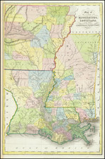
The Vicksburg Campaign
Rare separately published map of the area around Vicksburg, Mississippi, showing the military operations of the Union and Confederate Armies.
The map was compiled by in the offices of the United States Coast Survey, which at the time was the most advanced corps of mapmakers during the War. Executed by Charles G. Krebs, the map shows the military operations surrounding the siege of Vicksburg, extending from just west of Vicksburg to just east of Jackson, with Natchez and the northern border of Louisiana marking the north and south boundaries.
Krebs includes the major roads and railroads, along with many rivers and streams.
A red printed line shows the path Ulysses S. Grant's army, with troop emplacements and Union victories printed in red. The Union forces surrounding Vicksburg are illustrated, along with the tracks of General Blair and Admiral David Dixon Porter (rear admiral in command of the Mississippi River Squadron).
Union victories are marked by a small American flag.
With the beginning of the Civil War the United States Army found itself scrambling to obtain adequate field maps for military operations in the South. The most established cartographic branch of the government, the Coast Survey, was pressed into service to provide these maps. The cartographers of the Coast Survey meticulously reviewed all existing maps, then utilized the current military and scouting reports, along with the reports of covert government agents to assemble the most detailed possible maps detailing places, roads, railroads, and natural features.
Rarity
The map is quite rare on the market. We note only 2 examples listed in AMPR (Richard Fitch, 1994 and Murray Hudson, 2000).
![[Alabama, Mississippi, Arkansas, Louisiana and part of Tennessee and Western Florida] Amer. Sep. No. 56 Partie des États Unis](https://storage.googleapis.com/raremaps/img/small/93538.jpg)
![[Restricted] New Orleans (0-6)](https://storage.googleapis.com/raremaps/img/small/68648.jpg)