


|
||

|

|
|

|
Rare 1748 Edition
Detailed map of the British Colonies in North America, a decade prior to the French and Indian War.
From De Vaugondy's Atlas Portatif Universel et Militaire.
We have previously offered the 1749 edition several times, but this is the first time we have offered this 1748 edition.
Gilles Robert de Vaugondy (1688-1766) and Didier Robert de Vaugondy (1723-1786) were influential figures in the realm of 18th-century French cartography. Originating from Paris, their contributions to mapmaking were significant during an era of expansive geographical exploration.
Gilles Robert de Vaugondy entered the world of cartography not through family tradition but through personal interest and the budding opportunities of his time. Born in 1688, he worked during a time when Paris was becoming a central hub for cartographic activities. Gilles often incorporated the latest findings from explorers into his maps, making them sought-after for their contemporary relevance. His connections weren't limited to his immediate circle; he frequently interacted with other key mapmakers, staying updated on the latest techniques and findings.
His son, Didier, was born in 1723 and had the advantage of growing up surrounded by maps and globes. While his father was renowned for maps, Didier made a name for himself in the field of globemaking. His globes were some of the most precise and detailed in France, gaining recognition even among the royalty. In addition to his work in cartography and globemaking, Didier had a keen interest in education, especially after the expulsion of the Jesuits from France. He stepped in to produce geographical educational materials, fulfilling a newfound need.
The maps and globes produced by the Vaugondys remain an enduring testament to the peak of French cartography during the Enlightenment. Their works, characterized by precision and the inclusion of contemporary findings, helped to shape our understanding of the world during a transformative period in European history.
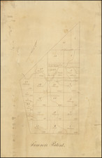
![[ New York State Western Frontier ] A Plan of Township No. Ten in the First Range - Each Lot Containing 192 Acres. Except the first Range of Lots on the South Side the Contents of which is Set against each Lot South. [Manuscript cadastral map of a portion of the Phelps and Gorham Purchase in Ontario County, New York].](https://storage.googleapis.com/raremaps/img/small/81444.jpg)

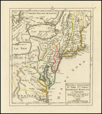
![Carte Particuliere de Virginie, Maryland, Pennsilvanie, La Nouvelle Jarsey. Orient et Occidentale [Heighten in Gold!]](https://storage.googleapis.com/raremaps/img/small/61392mp2.jpg)