|
||

|

|
|

|
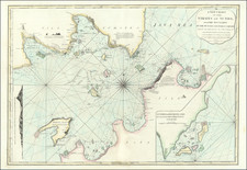
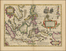
The First Printed Sea Chart of the Strait of Sunda
First state of Robert Dudley's rare early sea chart of the Strait of Sunda, from Sir Robert Dudley's Dell'Arcano del Mare.
The map illustrates the Straits of Sunda between the island of Sumatra and of Iava Maggiore, showing coastal towns, harbours and islands.
The map illustrates in fine detail the region which had been controlled by the Portuguese and completely inaccessible to Northern European trade until the second half of the 1590s, when the Dutch Compagnie van Verre (i.e. the Long-Distance Company) sent four ships under the command of Cornelis de Houtmann to the region, via the Indian Ocean, arriving on June 27, 1596, at Banten, Java. The information taken from the Portuguese directed the Dutch sailors to avoid the Malacca Strait–which was controlled by the Portuguese–and to sail through the Sunda Strait between Java and Sumatra.
In Java, de Houtman was introduced to the Sultan of Banten who promptly entered into an optimistic treaty with the Dutch. While Houtman's expedition was a commercial failure, within just a few years, the Dutch were actively trading in the region.
Dudley and the Arcano del Mare
Robert Dudley (1574-1649) is one of the most intriguing historical figures of the late Elizabethan period. His father, also named Robert and the first Earl of Leicester, was a favorite of Elizabeth I's. The Earl was a supporter of exploratory expeditions and backed Francis Drake on his circumnavigation (1577-1580) and Martin Frobisher on his 1576 voyage to find the Northwest Passage. Robert the Younger was the illegitimate son of the Earl and Lady Douglas Sheffield, born in 1574.
Dudley attended Christ Church, Oxford, starting in 1587. A year later, at only 14, Dudley stood by his father at Tilbury, witnessing Queen Elizabeth's famous speech in preparation for resisting the Spanish Armada. His father died in September that year, giving Robert a sizeable inheritance. In 1594, Dudley led an expedition to Guiana, where some of his men explored up the Orinoco River in search of gold. In 1596, Dudley joined an expedition against Cadiz.
All these experiences left Dudley in favor, and he thought the time was right to establish his legitimacy. In court proceedings from 1603 to 1605, Dudley fought for his right to his father's titles, but the Star Chamber ruled against him and he had to left England for self-exile in Italy. He settled in Florence, where he designed and built ships and advised Ferdinand I, Grand Duke of Tuscany.
While in Florence, Dudley also compiled all his sailing notes and thoughts on navigation (and those of others including, purportedly, Francis Drake, with whom he sailed in 1596, and Thomas Cavendish, to whom he was related by marriage) into a work called Arcano del Mare, or The Secret of the Sea. He finished the manuscript of the work in 1636 and published the work himself, at age 73, a decade later in 1646-7. It is there that this chart first appeared; it was reissued in 1661 in this second state.
The chart was compiled and drawn by Dudley, but it was engraved by Anton Francesco Lucini (1610-ca.1661). Lucini, a Florentine, did the engravings for Dudley's entire Arcano del Mare, which remain his most famous works. The fine scrollwork and distinctive style of Dudley's charts are due to Lucini, who spent 12 years and 5,000 pounds of copper in making the 200 plates and 146 charts.
It should be reiterated how important Arcano del Mare is to the history of cartography. It is the first sea atlas published by an Englishman. It is the first sea atlas to cover the entire world, not just the shores of Europe. It is the first to utilize the Mercator projection. This chart was the first to cover New Netherlands and New England in such detail. In short, this chart, and the atlas it originally accompanied, are monuments within the history of hydrography and cartography.
Rarity
Dudley charts are rare on the market. This is the first example we have offered for sale.
Robert Dudley (1574-1649) is one of the most intriguing historical figures of the late Elizabethan period. His father, also named Robert and the first Earl of Leicester, was a favorite of Elizabeth I’s. The Earl was a supporter of exploratory expeditions and backed Francis Drake on his circumnavigation (1577-1580) and Martin Frobisher on his 1576 voyage to find the Northwest Passage. Robert the Younger was the illegitimate son of the Earl and Lady Douglas Sheffield, born in 1574.
Dudley attended Christ Church, Oxford, starting in 1587. A year later, at only 14, Dudley stood by his father at Tilbury, witnessing Queen Elizabeth’s famous speech in preparation for resisting the Spanish Armada. His father died in September that year, giving Robert a sizeable inheritance. In 1594, Dudley led an expedition to Guiana, where some of his men explored up the Orinoco River in search of gold. In 1596, Dudley joined an expedition against Cadiz.
All these experiences left Dudley in favor, and he thought the time was right to establish his legitimacy. In court proceedings from 1603 to 1605, Dudley fought for his right to his father’s titles, but the Star Chamber ruled against him and he had to leave England for self-exile in Italy. He settled in Florence, where he designed and built ships and advised Ferdinand I, Grand Duke of Tuscany.
While in Florence, Dudley also compiled all his sailing notes and thoughts on navigation (and those of others including, purportedly, Francis Drake, with whom he sailed in 1596, and Thomas Cavendish, to whom he was related by marriage) into a work called Arcano del Mare, or The Secret of the Sea. He finished the manuscript of the work in 1636 and published the work himself, at age 73, a decade later in 1646-7.
Dudley’s Arcano del Mare (Mystery of the Sea) is one of the most important atlases ever produced and one of the most complex. It is the first sea-atlas of the whole world; the first with all the charts constructed using Mercator's new projection, as corrected by Edward Wright; the first to give magnetic declination; the first to give prevailing winds and currents; the first to expound the advantages of Great Circle Sailing; and the first sea-atlas to be compiled by an Englishman, albeit abroad in Italy. Dudley broke completely with the contemporary style of charts. He showed lines of latitude and longitude and omitted all compass lines. In doing so, his purpose was more intellectual than practical: techniques for determining longitude at sea were not refined until more than two centuries later. The maps are by English and other pilots and it is generally accepted that the work was both scientific and accurate for the time. Dudley used the original charts of Henry Hudson, and for the Pacific Coast of America used Cavendish's observations. The Arcano del Mare was a monumental and totally original task; the charts, representations of instruments, and diagrams all engraved on huge quantities of copper over many years with an exactitude incorporating the minutest detail and printed on the best possible paper.
Antonio Francesco Lucini, the engraver, was born in Florence c. 1610. Before being employed by Dudley, he had already engraved views of Florence and scenes of the Turkish Wars. In a printed introductory leaf found in one copy in the British Library, Lucini states that he worked on the plates in seclusion for twelve years in a Tuscan village, using no less than 5,000 lbs (2,268 kg) of copper.
![Plan der Stad en 't Kasteel Batavia Aanwyzing der Stad en Kasteels Punten [Map of the City and Castle Batavia Indication of the City and Castle Points.]](https://storage.googleapis.com/raremaps/img/small/93727.jpg)