|
||

|

|
|

|
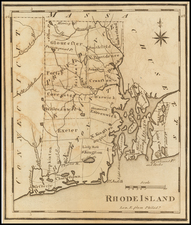
A Rare Map of Newport, Rhode Island and Vicinity
Rare map of the area around Newport, Rhode Island, first published in 1860.
The map offers a meticulous depiction of Newport and its roads, railroads, dwellings and other structures, including identifying landowners and numerous natural features.
Owing to the importance of Newport as a seaport, the map also includes soundings or the waters of Narragansett Bay.
The map is further embellished with historical notes and the outlines of fortifications at Fort Adams, Goat Island and elsewhere.
First issued in New York in 1860 by Matthew Dripps, the map was re-issued several times in Newport by A.J. Ward, including this edition and an edition issued in 1870. This edition lacks the Dripps imprint information and may have been issued after 1870.
Rarity
The map is rare on the market. We date our example based upon the information provided by the Library of Congress cataloging of this edition of the map.