


|
||

|

|
|

|
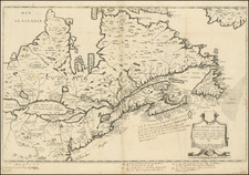
The First Map To Show Five Great Lakes and The Earliest Map of Canada To Incorporate The Work of Samuel De Champlain
Nice example of Jean Boisseau's edition of Samuel De Champlain's 1632 map, first published in Paris in 1643.
Boisseau's map was the first map derived from Champlain, pre-dating Pierre Du Val's important map of the region by 10 years. While it was long believed that Nicholas Sanson's map of 1650 was the first map to name and illustrate the 5 Great Lakes, in recent years it has been determined that Boisseau's "rare map is, in fact, the first printed to illustrate and name all five Great Lakes, pre-dating the Nicolas Sanson map of 1650. . ."
Burden notes that Boisseau's map takes the work of Champlain and makes a number of updates and improvements, adding the names that previously appeared only in Champlain's keys. There is no real recognition of the English presence in North America beyond 'Immestan' and 'Chesapeacq Bay'. The nomenclature in New England is entirely drawn from the work of Champlain.
On Champlain's map of 1632, both Lakes Erie and Michigan were unnamed. Here, Boisseau identifies the lakes as:
- Lac St. Louis (Lake Ontario)
- Lac Derie (Lake Erie)
- Mer Douce ou Lac (Lake Huron)
- Grand Lac (Lake Superior)
- Lac des Puans (Lake Michigan).
Boisseau also provides a much more accurate depiction of the lakes. Champlain's information here was secondhand, and thus he greatly underestimated its size. Most notably, Boisseau's depiction of "Mer Douce ou Lac" (Lake Huron) and "Grand Lac" (Lake Superior) are closer to their actual shapes. Lake Michigan may have been mistaken for the "Lac des Puans" to the northwest, or for the "Grande Riviere qui vient du Midy" that flows to the south. Nevertheless, as early as 1643 there were intimations in Europe that another great body of water still remained unexplored in the heart of North America.
Besides Champlain, Boisseau drew from other sources; for example, the naming of Chesapeake Bay is likely derived from John Smith.
Map States
There are two states of the map. The present example is the rare first state of Boisseau's map. A second state was issued circa 1664 without the imprint and date in the cartouche, and with the addition of London, Bristou, Gotenbourg, N. Amsterdam and Christina, along with degrees of longitude and latitude.
Rarity
This is the second example of the map we have offered in the past 25 years.

![[First Sea Chart of New Netherlands] Pascaarte van Nieu Nederlandt uytgegeven door Arnold Colom](https://storage.googleapis.com/raremaps/img/small/46535.jpg)
![[ Pictish Man Holding Severed Head ] Picti icon](https://storage.googleapis.com/raremaps/img/small/99837.jpg)
