


|
||

|

|
|

|
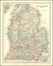
The First Family of Michigan Mapmakers
Fine example of Farmer's map of Michigan, published in Detroit in 1866.
Farmer's map is finely executed map, hand colored by counties and showing extraordinary detail throughout, including extensive annotations. Includes railroad tables and notes on the shipping lines in the Lake Michigan and Lake Huron, including routes.
John Farmer is perhaps the single most important map maker and surveyor in the history of the mapping of Michigan. Farmer was invited by Governor Cass and the trustees of the University of Michigan to move from Albany, New York to Michigan in 1821. His first major work was the surveying and creation of the first published map of Michigan. In 1825, he issued the first of a number of printed maps of Michigan, Wisconsin, Lake Superior, and Detroit, most of which he also engraved. In 1831 he compiled and drew for the governor and judges of the state the first and only map of Detroit. Farmer's early maps were extremely influential in promoting the extensive emigration to Michigan that occurred between 1825 and 1840. John Farmer's son, Silas, was born in Detroit, Michigan in 1839 and was brought up working in his father's business, where he continued the publication of maps well into the 1880s. For a period of time, Farmer's maps were licensed to J.H. Colton.
The present example, published in 1866, published by Farmer in Detroit under his own name.
Rarity
All of Farmer's maps are scarce on the market. This is the first example of the 1866 map and only the second example of Farmer's Rail Road & Township Map of Michigan and Chart of the Lakes which we have offered in the past 25 years.
![[ Great Lakes - Upper Midwest -- Western Canada ] Partie Occidentale Du Canada, contenant les cinq Grands Lacs, avec Pays Circonvoisons](https://storage.googleapis.com/raremaps/img/small/98377.jpg)
![The State of Ohio with part of Upper Canada, &c. [and Part of Michigan Territory within Ohio]](https://storage.googleapis.com/raremaps/img/small/102945.jpg)
![[ First map of Michigan Territory published in Europe ] Carte Geographique, Statistique et Historique De Michigan](https://storage.googleapis.com/raremaps/img/small/99266.jpg)
