|
||

|

|
|

|
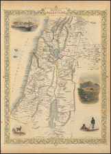
Rare early map of the Holy Land, one of the earliest printed maps of the Holy Land in English.
The map covers the Levant from Gaza north to Sidon. From an English language Bible, the woodblock shows major locations with numerous vignette illustrations of towns, mountains and forests and, at sea, ships and sea monsters.
Howard Golden describes the map as follows:
This comes out of the “Geneva Bible” the Pilgrims and Puritans brought to America.
In the middle of the 16th Century many English scholars and Puritans were forced to seek refuge abroad from the religious persecutions of Queen Mary's reign. Geneva had become a center of Protestant biblical scholarship and a team of English exiles led by William Whittingham, a scholar at Christ Church, Oxford, and soon to be Dean of Durham under Elizabeth, published an English New Testament in 1557 and a Psalter in 1559. In 1560, Miles Coverdale, another of the refugees, worked with him and others to produce an annotated Bible referred to as ‘The Geneva Bible’ for them and their families to use while in exile.
* * *
The complete Bible was financed by the English congregation in Geneva and was printed there by Rowland Hall in 1560 . . . Royal permission was obtained from Queen Elizabeth for its printing in England and the Geneva Bible was, in large measure, responsible for the spread of biblical knowledge among the rank and file of the English people and entered into the early history of America. Some call it the greatest gift of the Old World to the New.
![[Title page -- Book of Martyrs] Acts and Monuments of Matters Most speciall and memorable, happening in the Church, with an universall Historie of same . . . 1632](https://storage.googleapis.com/raremaps/img/small/79484.jpg)
![De Gelegentheyt van't Paradys en't Landt Canaan mitsgaders d'eerst bewoonde Landen der Patriachen uyt de H. Schristure …[Shows Cyprus]](https://storage.googleapis.com/raremaps/img/small/82746.jpg)