|
||

|

|
|

|
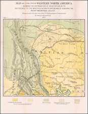
Illustrating Canadian Postal History -- A Cover's Travel Through the Northwest Passage in 1939
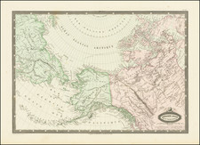
Fine large format map of the Northwest Territories of Canada, published by the Department of the Interior.
The map identifies:
- Royal Canadian Mounted Police Posts
- Radio Stations
- Trading Posts opened or maintained by permit
Of note, the map illustrates a westward northwest passage trip that is a part of Canadian Postal History. As noted in the Postal History Society of Canada Journal, No. 153, Spring 2013, in an article by Roy Lingen entitled Two 1938 Northwest Passage Covers, (p. 48-51):
In 1938, Major R.W. Hale (Postal Superintendent for the Northwest Territories) and Rev. Archibald L. Fleming prepared two sets of air mail covers, most of which were addressed to Hale in Edmonton. With the covers, Hale distributed pages bearing information on the paths of the covers. One set of covers was carried east through the Northwest Passage and the other west through the Passage. . . .
Hale wrote that the eastbound covers left Edmonton by plane on July 13, 1938 . . .
A westbound Northwest Passage cover is illustrated in Fig. 2. The westbound covers appear as Flight 613A, described as an exploratory mail test made by the Post Office Department, in the Canada section of the American Air Mail Catalogue (Volume 4). This mail left Montreal on July 9, 1938 in the Nascopie in care of Rev. Fleming, who looked after them until they reached Fort Ross. The covers were taken by dog team to King William Islands, from where they were taken in August 1939 in the Tudlik to Perry River. They were taken by R.C.M.P. dogteam patrol to Coppermine via Cambridge Bay, eventually reaching Edmonton on January 27, 1940. Figure 3 shows the facing slip for the forwarding of these covers from Fort Ross to Coppermine.
As noted below, the trip above matches perfectly with the above description. The map illustrates a route from Churchill (August 6, 1938) to Chesterfield (August 10), Wolstenholme (August13), Lake Harbour North Bay (August 17), Port Burwell (August 18), Thule, Greenland (August 24), Craig Harbour (August 26), Arctic Bay (no date given) and finally Fort Ross.
Thereafter, the route continued by Dogg Team beginning March 15, 1939, along the east side of Boothia Peninsula, past the magnetic pole and through Rae Strait to King William.
The trek next crosses to Chester Bay aboard the Eskimo motor ship M.V. Tudlik to Chester Bay, then northwest by dog team to Cambridge Bay, arriving November 29, 1939.
The trek continued on January 8, 1940 by Dog Team to Coronation Gulf, arriving at Richardson Bay on January 17, 1940.
The final leg of the journey was completed by air to Edmonton, January 25-27, 1940.