|
||

|

|
|

|
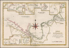
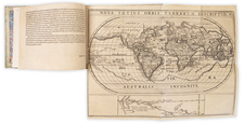
Sheet VI From The First State of John Green's Six Sheet Map of America
Southwestern Sheet of the extremely rare and historically important first edition of John Green's seminal chart of the Americas and the adjacent seas, published in London by Thomas Jefferys in 1753.
The influential map, in six sheets, was one of the most detailed maps of the Americas available to that date. Green wrote a pamphlet to accopmany the map, Remarks in Support of the New Chart of North and South America; in Six Sheets. The essay offered a biting indictment of his fellow mapmakers and a ringing endorsement for his own careful geographic composition.
Green's large map is made up of six sheets that join to show North and South America, along with large sections of the Atlantic and Pacific Oceans:
- Sheet I: Chart containing part of the Icy Sea with the adjacent coast of Asia and America. 43x52.5 cm (20¾ x 17").
- Sheet II: Chart comprizing Greenland with the Countries and Islands about Baffin's and Hudson's Bays. 52.5x61 cm (24 x 20").
- Sheet III: Chart containing the coasts of California, New Albion and Russian Discoveries to the North, with the Peninsula of Kamchatka, in Asia, opposite thereto, and Islands, dispersed over the Pacific Ocean, to the north of the line. 42.7x52.3 (20½ x 16¾").
- Sheet IV: Chart of the Atlantic Ocean, with the British, French & Spanish Settlements in North America and the West Indies. 42.3x60 cm (23¾ x 16½").
- Sheet V: Chart containing the greater part of the South Sea to the South of the Line, with the Islands dispersed thro' the same. 42.7x52.3 cm (20½ x 16¾").
- Sheet VI: Chart of South America, comprehending the West Indies, with the adjacent Islands, in the Southern Ocean, and South Sea. 53.3x59.8 cm (23½ x 21")
Green’s map was innovative and showed the latest discoveries, including those of the Russians along the coast of what is today Alaska. For example, this map is widely considered the first to assign the name Bering to the strait between Asia and North America, i.e. "Behring's Straits" or the Bering Strait today. Bering refers to Vitus Behring, who led two expeditions (1728-30, 1733-43) that probed Kamchatka and Alaska and the waters in between.
Many other explorers' routes are also plotted, with illustrations of exploration dating from the sixteenth century onward. The reason for including so many is explained in a note in the Pacific, “These Tracks of Shipping are inserted to make known the Navigation of this Ocean and encourage the discovery of a Passage on this side Northward.” There are many other notes and commentaries, particularly surrounding Hudson’s and Baffin Bays, revealing Green’s meticulous research and interest in a Northwest Passage.
Green includes many fascinating geographic features that appear fantastical to the modern eye, but which were valid cartographic ideas in the eighteenth century. As just two examples, on the west coast of North America, Green has hypothesized a River of the West headed inland from an “opening discovered by Martin D’Aguilar in 1603.” Martin de Aguilar was a Spanish captain who sailed with Sebastian Vizcaino on a reconnaissance expedition up the California coast in 1602-3. Aguilar, commanding the Tres Reyes, was blown off course, to the north. When the seas calmed, Aguilar reported that he had found the mouth of a large river. Eighteenth-century geographers, including Joseph Nicholas Delisle and Philippe Buache, conjectured that the river was the entrance to the Sea of the West. Green prefers a river to a sea, but still thinks there might be something in stories of Aguilar’s journey.
The second example of interest is the tiny island just off the east coast of Patagonia, Pepy’s Island. Pepys Island is named for Samuel Pepys, Secretary to the Royal Navy in the late seventeenth century. The island was first sighted by pirates in 1683 but would prove to be chimerical by the 1760s. In the 1750s, however, the island was an accepted geographic fact, even though no one had ever set foot there.
There are many comparative tables that dot the charts. These show Green’s calculations of latitude and longitude as compared to those of other mapmakers’, particularly the widely-acclaimed French mapmakers like Buache and Jacques-Nicolas Bellin. He also mentions his improvements on the work of the popular English mapmakers Herman Moll and John Senex.
These tables show just how aware Green was of the competitive nature of the international map market. He used his research to set himself apart. He also used the most recent information. For example, a table in what is now British Columbia gives the latitudes and longitudes of sixteenth century Spanish journals so that the reader could compare them to the coast as plotted. The coordinates for this table were taken from a Spanish chart stolen by Commodore George Anson when he captured the Covadonga treasure galleon in 1743, ten years before this chart was made.
Criticizing the Buache/Delisle map
This first edition of Green’s six-sheet map was designed in part to expose the errors in Joseph Nicholas Delisle and Buache’s map of the Pacific Northwest published in June 1752. This map, a collaboration between the famed Guillaume Delisle’s brother and son-in-law, was one of the first to illustrate the extent of the Russian discoveries in the 1730s and 1740s, as well as published a Sea of the West which Guillaume had hypothesized but never printed. They also put place to three apocryphal, or least exaggerated, voyages, led by Martin Aguilar, Juan de la Fuca, and Admiral de la Fonte.
It was the placement of the latter’s discoveries that incensed Green. Admiral de la Fonte supposedly sailed to the Pacific Northwest in the mid-seventeenth century. The first mention of Fonte appears in two letters published in London in 1708 in two issues of The Monthly Miscellany or Memoirs for the Curious. The Fonte letters had been reprinted by Irish MP and Northwest Passage enthusiast Arthur Dobbs in his An Account of the Countries adjoining Hudson’s Bay (1744) and were mentioned in other travel accounts. Delisle’s copy of the letters came from Lord Forbes, British ambassador to Russia, as Delisle explained in a memoir, Nouvelles Cartes des Decouvertes de l’Amiral de Fonte (Paris, 1753). He also read of them in Henry Ellis’ account of the 1746-7 expedition to Wager Inlet in Hudson Bay.
The letters recounted that Fonte had found an inlet near 53°N which led to a series of lakes. While sailing north east, Fonte eventually met with a Boston merchant ship, commanded by a Captain Shapley, which had sailed north and east round the continent. One of Fonte’s captains, separated from the Admiral, reported he had found no strait between the Pacific and the Davis Straits, yet had reached 79°N, helped by local indigenous peoples. This story, with its suggestion of water passages connecting the Pacific Northwest with the Atlantic, inspired hope in some and doubt in others in the mid-eighteenth century.
A few, like Green, thought the entire story a farce. In a memoir published along with this map, Green explained that in the June 1752 edition of the Delisle/Buache map, Fonte’s entrance was at 63°N latitude, not 53°N as the letters said. Green thought this was duplicitous and concluded “that Messieurs Delisle and Buache…were conscious the Discoveries ascribed to De Fonte were spurious, at the same Time they adopted them” (iii). Green reveals in a postscript to the memoir that while his work was at press, Delisle issued a new map of the same area, with the Fonte latitude corrected. Both Buache and Delisle, no longer working together, continued to believe in Fonte as a source, however, much to Green’s derision. On his own map, he left the interior of what is now Northwest Canada blank, except for a comment:
These parts, as yet wholly unknown are filled up, by Messrs. Buache and Del’Isle, with the pretended Discoveries of Adm. De Fonte and his Captains in 1640.
John Green/Bradock Mead
As can be gleaned from his comments, Green was one of the most intriguing figures in British cartographic history. John Green (a.k.a. Bradock Mead), a Dubliner, led a scandal-fueled lifestyle that stood in marked contrast to his meticulous scientific approach to cartography. He was an extremely gifted, but troubled mapmaker who compiled many of the maps for prolific English cartographic publisher Thomas Jefferys (ca. 1710-1777). As you can read in the biography below, he led quite an interesting life, in addition to making excellent maps.
This map is a testament to that fact; it is a brilliantly detailed example of the changing geography of the Americas in the eighteenth century, particularly in the Pacific Northwest and Pacific regions. The first edition is also rare on the market, particularly in as nice a condition as this example. This set of six-sheets would make form the cornerstone of any collection of Americas maps, or maps of exploration.
G. R. Crone, “Further Notes on Bradock Mead, alias John Green, an eighteenth century cartographer,” Imago Mundi 8 (1951): 69-70.
John Green, Remarks, in support of the New chart of North and South America; in Six Sheets (London: Thomas Jeffreys, 1753).
Warren Heckrote and Edward H. Dahl, "George le Rouge, Vitus Bering, and Admiral la Fonte: a Cautionary Tale about "Cartographic Firsts"" The Map Collector 64 (autumn 1993): 18-23.
Lucie Lagarde, "Le Passage du Nord-Ouest et la Mer du l'Ouest dans la Cartographie Francaise du 18e Siecle," Imago Mundi 41 (1989): 19-43.
Mary Sponberg Pedley, The Commerce of Cartography: Making and Marketing Maps in Eighteenth-Century France and England (Chicago: University of Chicago Press, 2005).
H. R. Wagner, "Apocryphal Voyages to the Northwest Coast of America," Proceedings of the AAS XLI (1931): 179-234.
Glyndwr Williams, “An eighteenth-century Spanish investigation into the apocryphal voyage of Admiral Fonte,” Pacific Historical Review 30, no. 4. (1961): 319-327.
Thomas Jefferys (ca. 1719-1771) was a prolific map publisher, engraver, and cartographer based in London. His father was a cutler, but Jefferys was apprenticed to Emanuel Bowen, a prominent mapmaker and engraver. He was made free of the Merchant Taylors’ Company in 1744, although two earlier maps bearing his name have been identified.
Jefferys had several collaborators and partners throughout his career. His first atlas, The Small English Atlas, was published with Thomas Kitchin in 1748-9. Later, he worked with Robert Sayer on A General Topography of North America (1768); Sayer also published posthumous collections with Jefferys' contributions including The American Atlas, The North-American Pilot, and The West-India Atlas.
Jefferys was the Geographer to Frederick Prince of Wales and, from 1760, to King George III. Thanks especially to opportunities offered by the Seven Years' War, he is best known today for his maps of North America, and for his central place in the map trade—he not only sold maps commercially, but also imported the latest materials and had ties to several government bodies for whom he produced materials.
Upon his death in 1771, his workshop passed to his partner, William Faden, and his son, Thomas Jr. However, Jefferys had gone bankrupt in 1766 and some of his plates were bought by Robert Sayer (see above). Sayer, who had partnered in the past with Philip Overton (d. 1751), specialized in (re)publishing maps. In 1770, he partnered with John Bennett and many Jefferys maps were republished by the duo.
John Green is an alias for Bradock Mead (ca. 1688-1757). Raised in Dublin, his brother Thomas, served as Lord Mayor of the city in 1758-9. While in Dublin, he published The construction of maps and globes (London: 1717). He also became involved with a plot to kidnap an heiress. He escaped, but others in his group were not so lucky. He came to London and took on the name Rogers and worked as an amanuensis.
He was active in London from at least the early 1720s to 1755. Later, as Green, he translated du Halde’s Description géographique de la Chine into English for the publisher Edward Cave. He also worked on Astley’s voyage collection. However, he fell out with both men. From the 1730s onward, he worked periodically with Thomas Jeffreys, Geographer to Frederick Price of Wales and later to King George III. In 1757, he committed suicide by jumping from a third-story window.
![A Geographical Chart: or, A Scheme, Comprehending The Most Important Particulars Relative To The Geography of North and South-America. : Designed to be an Auxiliary to the Student. Carefully Compiled from the Best authorities, by Amos Bingham [Copy-Right Secured]](https://storage.googleapis.com/raremaps/img/small/41406.jpg)