This item has been sold, but you can enter your email address to be notified if another example becomes available.


|
||

|

|
|

|
Stock# 59982
Description
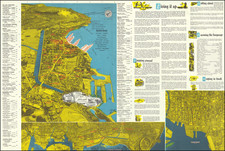
Detailed map of Oahu, from the Hawaiian Territorial Surveys.
The map was compiled from government surveys and from private surveys by John M. Donn.
The legend identifies by color a number of different land uses, including:
- Public Lands
- Sisal Plantations
- Homestead Settlement Tracts
- Grazing lands
- Pineapple lands
- Federal Reservations
- Sugar Plantations
- Forest Reserves and other forest lands
- Wet lands
Schools and post offices are also located.
Condition Description
Minor discoloration at folds.