|
||

|

|
|

|
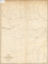
From Dougherty's Landing on the Missouri River to Coal-Fired Power Plant -- Iatan, Missouri
Finely executed town plan for Iotan [Iatan], Missouri, in Platte County, Missouri drawn on Whatman watermarked paper dated 1821, likely drawn by then Captain Thomas Swords.
Based upon the date below on which the first plat map of Iatan was filed (May 22, 1841) and the buyout of one of the three founding partners in November 1843, the present map would almost certainly have been drawn sometime in the second half of 1841 and periodically annotated to add the names of new property owners, which can be faintly seen in the lots closest to the Missouri River.
The 3 founders of the town included (1) Major John Dougherty, an important early Indian Agent with ties to William Clark and Benjamin O'Fallon, (2) General Thomas Swords, then a young Captain at Ft. Leavenworth, Kansas, where he served as Assistant Quartermaster from 1834 to 1842, and (3) J.G. Shultz, the son of a Maysville, Kentucky Merchant, who also acquired land near Bean Lake from Benjamin Bean in 1837.
The maker of the map is not given, but almost certainly done by then Captain Thomas Swords, a West Point Graduate (1829), with a known history as a mapmaker, dating back to his map of West Point (now in the Smithsonian Institute) done while he was a Cadet in 1825. https://americanhistory.si.edu/westpoint/history_1_pop4.html. Swords would later accompany General Stephen Kearny in the conquest of New Mexico and California, raise the first American flag over Santa Fe and fight in the Battle of San Pasqual, California, during the Mexican War, before serving as chief quartermaster of the Departments of the Cumberland and the Ohio, during the Civil War.
History of Iatan, Platte County Missouri
Iatan was one of the earliest towns in the region immediately north of Kansas City, founded by one of the most important early Indian Agents in the region. The Leavenworth Weekly Times of April 22, 1908 tells the story of the founding as follows:
The Founding of the Village of Iatan
Oak Mills, April 22. -- Just across the river from his place and about twelve miles north of Leavenworth, is one of the oldest settlements in this section of the country. About 1837 or soon after the Platte Purchase, Major John Dougherty "entered" the land on the present site of Iatan and it became known as Dougherty's Landing. In 1841, Major Doughtery, Thomas Swords, and J.G. Shultz formed a company and laid off a townsite at the place, the plat being filed on May 22 of that year. On Nov 30, 1843 Shultz sold his third to Dougherty and Swords, who obtained a charter for the town. Shultz accidentally killed himself Nov. 6, 1854.
The town was named Iatan by Major Dougherty in honor of an Otoe Indian chief of that name, who was a great friend of the whites during that time that Major Dougherty was Indian Agent for the Upper Missouri river territory. The town of Iatan had a boat landing during the steamboat days, a mille was built in the early '40s and other enterprises started, but the patronage of the settlers soon diverted to more promising towns of Weston and St. Joe, and Iatan never amounted to much as a municipality, always remaining a mere hamlet of several dozen souls.
Two notes in the Annals of Platte County, Missouri . . .(1897) read
- DATES OF FILING TOWN PLATS, AND BY WHOM: . . . latan, May 22, 1841 Dougherty, Swords & Shultz.
- Nov. 30 — J. G. Shultz sells to Dougherty & Swords his interest in the site of Iatan.
Dougherty named the town for Iotan, chief of the Otoes. Dougherty was probably also aware that the bluffs behind Iatan contained the largest Indian mounds in the region. George Remsberg, an Atchison archeologist, would later open several mounds in 1896. Over the years, many pottery shards, bones, and artifacts have been found in the bluffs.
The Original Iatan Townsite is now Missouri's Largest Coal Fired Power Plant
The current location of Iatan appears to now be deceptively northeast of the original location on the Missouri River. It would appear that the lands shown on this map are now the location of the Iatan Steam-Electric Generating Plant and is currently The Iatan 1 and Iatan 2 coal-fired power stations for Kansas City Power & Light, the largest coal-fired generating plant in Missouri.
The Iatan 1 plant which opened in 1980 has a 651-megawatt capacity and had a 700-foot (210 m) high chimney when it opened. The tower is higher than any occupied building in the state including the Gateway Arch. The Iatan 2 plant opened in 2010 and can generate 850 Megawatts with a capacity to burn 494 tons of coal per hour. The new plant has a lower 60-foot (18 m) high mechanical cooling tower.
Manuscript Information on the Map
While a number of the names on the numbered lots are illegible, 3 names are very clear:
- Lot 31: Swords
- Lot 26: Shultz
- Lot 18: Dougherty
On the verso, a transfer of land is apparently being described.
- ??? ??? Ruff 2/3 (Charles Frederick Ruff?)
- " C Augusta Swords 1/3
John Dougherty
John Dougherty was born in 1791 in Kentucky. He moved to St. Louis in 1808, then signed on with the Missouri Fur Company in 1809, where he spent the next ten years, learning to speak French and numerous Indian dialects fluently. In 1819 and 1820 served as an interpreter for Major Stephen H. Long's expedition, serving as translator for Major Benjamin O'Fallon. He then served as sub-agent and interpreter with the Upper Missouri Agency at Fort Atkinson under Major Benjamin O'Fallon until 1827, when O'Fallon resigned and Dougherty became United States Indian Agent at Fort Leavenworth, where he was given the rank of Major and served as Indian agent, reporting to William Clark, Superintendent of U.S. Indian Affairs
Dougherty was the author of a plan to further separate the Indian Territory from the encroaching white settlers. In December 1834, he proposed establishment of frontier posts from the Upper Mississippi to the Red River of the South, linked by a military road patrolled by U. S. Dragoons. In 1835, the citizens of Clay County petitioned the United States Senate for protection from the Indians and establishment of Dougherty's plan. On July 2, 1836, President Jackson signed the act providing for the road and $100,000 to build it.
In Spring 1835, Dougherty he was lobbying in Washington for the Platte Purchase and attended a Clay County meeting that summer with David R. Atchison, Alexander William Doniphan and William T. Wood planning an approach to Congress to add the area to Missouri. He was back at Ft. Leavenworth in 1836, when William Clark negotiated the Platte Purchase treaty with Iowas and Sacs and Foxes of Missouri, which Dougherty witnessed Indian Agent.
An 1837 reorganization in the Indian Department again reduced Dougherty's agency to only the Otoes, Missouris, Omahas and Pawnees. In 1838, Dougherty was a temporary subagent at the Great Nemahaw agency where he negotiated a treaty with the Iowas confirming ceding of all lands between the Mississippi and the Missouri in exchange for $157,500 invested for the tribe at not less than 5% with annual payments of income.
In 1837, Dougherty purchased a large estate near Liberty, in Clay County, Missouri.
When Clark died in 1838, Dougherty was his natural successor, but lacked the political connections necessary to secure the position. Instead Joshua Pilcher succeeded Clark as the new Superintendent. Dougherty resigned from government service in 1839. He moved to Missouri and, making use of his western affiliations, went into business with Colonel Robert and William Campbell of St. Louis as a sutler and freighter from 1839 to 1855. Dougherty was elected to the Missouri Legislature on the Whig Party ticket in 1840. He semi-retired in 1855 and managed a sizeable estate in Clay County, Missouri.
George Catlin commenting on Dougherty - “by unrelenting endeavors, with an unequalled familiarity with Indian character and unyielding integrity of purpose, has successfully restored and established a system of good feeling between them (the Pawnees) and (the whites) upon whom they looked, naturally and experimentally as their destructive enemies."
Provenance: Reported to have accompanied a Missouri emigrant in search of gold to John Fremont’s Rancho Las Mariposas during the California Gold Rush. This map, along with our Hutawa map of the Platte Country, remained in the possession of the family until the 1960’s when both maps were gifted to a private Mariposa, California collector.
Thomas Swords was a grandson of Captain Thomas Swords, a British officer, who died in New York in 1780. His father was the senior member of the publishing-house of T, and J. Swords, of New York city.
Swords graduated from the United States Military Academy in 1829, assigned to the 4th infantry, and served in various parts of the southern states for four years, when he was appointed First Lieutenant in the 1st Dragoons.
Swords was promoted Captain on March 3, 1837, and during nearly the whole of the succeeding twelve years was engaged on frontier duty, serving with General Henry Leavenworth against the Indians in the southwest, and with General Stephen Kearny in the conquest of New Mexico and California, and raised the first American flag over Santa Fe.
When General Kearny's force reached San Diego in January, 1847, Swords, who was the quartermaster, went to the Sandwich islands and obtained clothing and supplies for the soldiers. He became captain and assistant quartermaster on July 7, 1838, Major, April 21, 1846, and Lieutenant-Colonel and Deputy Quartermaster-General on August 3, 1861.
Swords was Chief Quartermaster of the Army of the West in 1846-47, where he fought at the battle of San Pasqual, California, in December, 1846, and at Vera Cruz, and was brevetted Lieutenant-Colonel on May 30, 1848, for meritorious services in the enemy's country.
During the Civil War, Swords was chief quartermaster of the Departments of the Cumberland and the Ohio from 1861 to 1865, was engaged in the battle of Chickamauga, and brevetted Brigadier-General and Major-General on March 13, 1865.
He retired from active service in February, 1869.