|
||

|

|
|

|
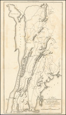
First state of the best atlas map of New York State published in the 19th Century.
This vividly colored example is richly annotated throughout the map with various regional details on various rivers, roads and other local features.
The early counties are shown in remarkable detail, from original surveys. Includes roads, rivers, lakes, turnpikes, villages, mills, ironworks, forts, post offices, battle grounds, places of worship, public houses, roads, ferries, falls, etc.
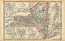
Tanner commenced production of his most ambitious project, his American Atlas, in 1818. Released in 5 folios between 1819 and 1823, the Atlas is widely regarded as the single most beautiful large scale American Atlas ever published. The maps are large, detailed and elegantly engraved. The production resulted in the split of Tanner from his partners Kearney & Vallance, but resulted in the greatest of American Atlases.

![(Colonial New York) [Deed of Partition of a Tract of 10,200 Acres of Lands to the Eastward of Fort Edward in Charlotte County]](https://storage.googleapis.com/raremaps/img/small/93927.jpg)