


|
||

|

|
|

|
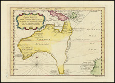
Nice example of De Wit's map of Southeast Asia, engraved by Joannes Lhulier in 1662.
The map shows from southeastern Persia to northwestern Australia. Focus is on India, Southeast Asia, and the East Indies with the Phillipines. The many islands are clearly depicted, with ports shown as the most important information. The Celebes Islands were then being developed for the spice trade which would lead to hostilities among the European powers. This map served as the prototype for Speed's map of SE Asia, issued by Francis Lamb in the 1676 edition of Speed's Atlas.
De Wit (1629 ca.-1706) was a mapmaker and mapseller who was born in Gouda but who worked and died in Amsterdam. He moved to the city in 1648, where he opened a printing operation under the name of The Three Crabs; later, he changed the name of his shop to The White Chart. From the 1660s onward, he published atlases with a variety of maps; he is best known for these atlases and his Dutch town maps. After Frederik’s death in 1706, his wife Maria ran the shop for four years before selling it. Their son, Franciscus, was a stockfish merchant and had no interest in the map shop. At the auction to liquidate the de Wit stock, most of the plates went to Pieter Mortier, whose firm eventually became Covens & Mortier, one of the biggest cartography houses of the eighteenth century.

![[ Beijing ] Peking](https://storage.googleapis.com/raremaps/img/small/101285.jpg)