|
||

|

|
|

|
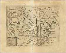
Portuguese Manuscript Chart of the Río de la Plata River Basin
Highly-detailed chart of the riverine basin that today makes up Uruguay and southern Brazil. The chart, in Portuguese, dates from the mid-eighteenth century, when this area, known as the Banda Oriental, was the center of an ongoing dispute amongst the Spanish and Portuguese Empires.
The chart labels all the rivers and streams in river basin, which today comprises Uruguay, the Brazilian state of Rio Grande do Sul, and parts of Argentina. It shows sandbanks and other obstructions in Río de la Plata and exaggerates the size of the Paraná River to show the many islands that dot the waterway. Some interior topographical details are also included, mainly hills.
Several settlements are marked, including Buenos Aires and Montevideo. The latter was founded in 1724, suggesting a date range for the map, which has early-eighteenth century handwriting. At the north of the long Lagoa dos Patos is another town, Viamão. Established initially in the 1740s, Viamão became the capital of the captaincy during the Spanish invasion of 1766. It remained the capital until 1773, when neighbor Porto Alegre was founded and named as capital. Porto Alegre is not on this chart, suggesting a creation date of pre-1773.
It is likely that the chart dates from the 1760s, when Portugal and Spain were fighting over control of the Banda Oriental. According to the Treaty of Tordesillas, Portugal was only supposed to expand to 370 leagues west of the Cape Verde Islands, or to roughly the 46th meridian. However, in practice, Brazil had spread far more than the treaty originally allowed and the rugged terrain and long distances meant that the treaty was hard to enforce.
By the eighteenth century, the area had become the focus of territorial disputes between the Spanish and Portuguese empires, not to mention the Jesuits who had founded missions in the area and farther west in what is today Paraguay. One conflict centered on what is now Montevideo. When the Portuguese began to fortify the area in 1723, the Spanish became nervous. Early in the next year, the Spanish sent an expedition to harass the Portuguese fortification. They succeeded in routing the Portuguese defenders, leaving the city to Spanish control.
In 1750, Spain and Portugal signed a landmark treaty meant to settle the territory question once and for all. The Treaty of Madrid was based on the principles of Uti possidetis, ita possideatis; from Roman law, it means “he who owns by fact owns by right.” In effect, the Treaty recognized the de facto situation on the ground in South America and upheld natural geographic boundaries. The preamble states, “each party must stay with what it now holds,” and, “the boundaries of the two Domains... are the sources and courses of the most notable rivers and mountains.”
This authorized the Portuguese to retain the lands they had long occupied at the expense of the Spanish Empire. The treaty also stipulated that Spain would keep Colonia do Sacramento, situated directly across the Río de la Plata from Buenos Aires, while Portugal would gain the Misiones Orientales, seven independent Jesuit missions east of the upper Uruguay River.
The treaty sought to follow geographic features in fixing the boundary: it moved westward from a point on the Atlantic coast south of Río Grande do Sul, then northward irregularly following parts of the Uruguay, Iguaçu, Paraná, Paraguay, Guapore, Madeira, and Javari Rivers. North of the Amazon, it ran from the middle Río Negro to the watershed between the Amazon and Orinoco basins and along the Guiana watershed to the Atlantic.
The Treaty of Madrid was significant because it substantially affected the modern boundaries of Brazil. However, it also called for the removal of the seven Jesuit missions of the Misiones Orientales west of the Uruguay River. Guaraní people who lived on the estancias were expected to relocate. The Guaraní, led by Sepé Tiaraju, rejected Portuguese rule and the order to relocate.
Instead, they fought for their lands, with the conflict erupting into the Guaraní War in 1754. The dispute simmered from 1754 to 1756, then broke out again in 1756 when a Spanish-Portuguese force sought to quell the remaining Guaraní fighters. Sepé Tiaraju was killed and, three days later, over 1,500 of his warriors were slain at the Battle of Caiboaté; only 4 Spanish and Portuguese soldiers were killed.
The disappointment of the Jesuits at surrendering their missions and the active resistance of the Guaraní against forced their relocation contributed to the nullification of the Treaty of Madrid by the subsequent Treaty of El Pardo, signed by both empires in 1761.
A year later, in 1762, a Spanish force under Don Pedro Antonio de Cevallos invaded Rio Grande do Sul and took possession of several fortresses and towns. The Treaty of Paris, which ended the Seven Years’ War, returned this land to Brazil, but Spain maintained its control of several towns, including Rio Grande de S. Pedro, which is marked on this map.
Just three years later, the imperial powers again went to war. The Portuguese attacked the Spanish at Rio Grande and the Spanish retaliated swiftly. Cevallos was promoted to Viceroy of Río de la Plata and made commander of the Spanish forces. With a fleet from Cadíz, Cevallos took the island of Santa Catarina and then proceeded to Rio Grande. However, en route, he got word that negotiations for peace were underway.
In the Treaty of San Ildefonso (1777), Spain returned Santa Catalina to Portugal, but they received definitive power over Colonia do Sacramento. They also took much of the Banda Oriental, including the Misiones Orientales. The dispute continued into the nineteenth century when the Empire of Brazil and the United Provinces of Río de la Plata fought the Cisplatine War (1825-1828), after which Uruguay was declared an independent state.
This map shows an exciting area during an important time in its history. It is a rare survival with rich detail that would augment any collection of Uruguayan, Brazilian, or South American maps.
![[Straits of Magellan] Carte Reduite Du Detroit De Magellan Dressee sur les Journaux des Navigateurs; Par le Sr. Bellin . . . 1753](https://storage.googleapis.com/raremaps/img/small/66318.jpg)