|
||

|

|
|

|
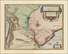
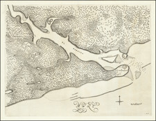
Early Portuguese Manuscript Map of Rio Grande de São Pedro in Brazil
Striking Portuguese manuscript map of Rio Grande de São Pedro, now called Rio Grande, in southern Brazil.
The map shows the town and surrounding terrain of Rio Grande, which is where the Lagoa dos Patos meets the Atlantic Ocean. The lagoon is the largest in Brazil and the largest barrier-lagoon in all of South America. This northeast-oriented map shows just the southernmost part of the 174-mile-long lagoon. Several sounding depths are included near the inlet, suggesting a sailing route from the sea into the lagoon.
The land is dotted with pen marks, perhaps to show vegetation or other details. Two roads, to Chuý and Tururitama, are marked. Numbers are scattered over the terrain, identifying local landmarks. Although there is no key, several of the numbers are identifiable. Number 2, at the top, is the Ilha dos Marinheiros, and the Ilha do Machadinho is number 5.
The town of Rio Grande is located on the peninsula that snakes through the middle of the map. Several of the key items, marked with numbers, are at the tip of this peninsula and it is likely that number 9 represents Forte Jesus, Maria, José do Rio Grande.
At the center top is an ornate cartouche with the title, north arrow, and scale. In the bottom corners are two shields with spears. These are blank, though drawn with care. It is likely the maker intended to fill these with text, perhaps the key to the numbers on the map.
Paleography and style suggest a date of creation in the mid- to late-eighteenth century. As Rio Grande was founded in 1737 and the outpost at Chuý in 1751, this map must have been made after those dates. The Spanish controlled Rio Grande from 1763-1777, but the map is written in Portuguese. The development of the town as shown here indicates a date of ca. 1780, when the Portuguese had regained the fort and town.
Rio Grande
Rio Grande is located in a strategic spot in the highly-contested Banda Oriental, which is today the southernmost part of Brazil and the country of Uruguay. In 1737, Jose da Silva Paes was ordered to secure Brazil’s claim over these southern lands. As part of his military expedition, he founded a fort at Rio Grande in February. By May, the settlement had been recognized by the Portuguese Crown. Beyond its strategic importance as a stronghold in the simmering conflict between Spain and Portugal as to the borders of their respective colonies, Rio Grande was also a port that served the estancias, or large farms and ranches, that were near the lagoon.
In 1763, conflict boiled over. The Spanish, led by Pedro de Ceballos, the governor of Buenos Aires and the first viceroy of Río de la Plata, invaded the Banda Oriental and took over Rio Grande. Despite Portuguese attempts to dislodge them, the Spanish maintained possession of the town until 1776. On the first of April of that year, Johann Heinrich Bohm, the general of Portuguese forces in the area, took back the fortress. Cebollas menaced the town again the following year, but news of the Treaty of Ildefonso halted his advance.
This map was likely made soon after the Portuguese regained the town. Today, the town is the oldest in the Portuguese state of Rio Grande do Sul. It remains a vibrant port city—the second busiest in Brazil— renowned for its beaches and made wealthy by industry, especially its large oil and gas refinery.
This manuscript map is skillfully and strikingly drawn. It captures an important city in a region long contested by two empires. It would make a unique addition to any collection of Brazilian maps.
![Carte Du Paraguay . . . [showing Rio Janeiro, Buenos Aires, Salta, etc]](https://storage.googleapis.com/raremaps/img/small/101636.jpg)