![[English Edition!] Maris Pacifici quod vulgo Mar del Zud By Abraham Ortelius](https://storage.googleapis.com/raremaps/img/small/71000.jpg)


|
||

|

|
|

|
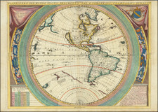
The First Map of the Pacific Ocean from the First Modern Atlas
Fine old-color example of Ortelius' “Maris Pacifici”, the first stand-alone map of the Pacific ever printed. It was featured in Theatrum Orbis Terrarum, the first modern atlas.
Ortelius’ Pacific, while vast, shows a much-smaller body of water than the Pacific turned out to be. However, methods for measuring longitude were still uncertain in the late-sixteenth century, and Ortelius, dependent on information brought back by navigators, was working from a limited data set.
North America mushrooms in the north, stretching as far west as New Guinea, which is also of grandiose size. Tucked into the label for North America, Americae Septemtrionalior Pars, is another place name, Quivira. Quivira was common on maps of North America of the time and refers to the Seven Cities of Gold sought by the Spanish explorer Francisco Vasquez de Coronado in 1541. In 1539, Coronado wandered over what today is Arizona and New Mexico, eventually heading to what is now Kansas to find the supposedly rich city of Quivira. Although he never found the cities or the gold, the name stuck on maps of southwest North America, wandering from east to west.
The treatment of America shown here, and most notably the Pacific Northwest area, is reminiscent of Jodocus Hondius' portrayal of the continent. This map and Hondius/Le Clerc's map of 1589 (known only in the 1602 edition) have a curious and not fully understood relationship. Scholars debate which is truly the first map of the Pacific although, because no example of the original 1589 Hondius/Le Clerk has been discovered, this map retains primacy.
Japan is mis-projected, revealing how little was known about the geography of the archipelago at this time. To the north is a large island supposedly rich in gold, Isla de Plata. This could be a reference to Hokkaido or to a chimerical island in the North Pacific.
Tucked between Japan and North America is a block of text which translates to:
In the region of China, as also of Japan and the neighboring isles, many have been won for the Christian faith by the fathers of the Society of Jesus, going to the settlements in the new Indies, as a result of their efforts.
Francis Xavier, a Jesuit, entered Japan in 1549, and he began to convert Japanese people to Christianity. The Jesuits tried to enter China in 1552, again led by Xavier, but they succeeded in gaining more permanent entry only in the early 1580s, led by Matteo Ricci.
To the south are the Moluccas and the Philippines, already the sites of intense European focus with the Spanish in the latter and the Portuguese vying to control trade with the former. However, the Dutch and the English would join the trade in growing numbers in the decade following this map’s initial creation.
New Guinea is massive and appears very different as compared to Ortelius' world map of 1587 and his map of America, also of 1587. These were made only two years before the first state of this map, yet on the former New Guinea is an island shaped differently than on this example, and on the latter New Guinea is not an island at all. This suggests that Ortelius was continuously updating his maps based on new sources and reinterpretations of old sources, showing his never-ending process of compilation and research. Ortelius also includes an alternative name for New Guinea, Terra de Piccinacoli, which reveals a further source. On his 1564 world map, Ortelius explains that the Piccinacoli place name came from Andrea Corsali, an Italian explorer.
Another notable observation about New Guinea is that it is disconnected from Terra Australis. Most contemporaries of Ortelius surmised that New Guinea was a promontory of a huge southern continent. Tierra del Fuego, however, is part of this southern landmass. Ortelius describes the southern continent as “nondum detecta,” or not yet detected. To Ortelius, like his many of his colleagues, it was only a matter of time until someone confirmed the existence of a large Terra Australis.
Just east of New Guinea are the Solomons. This island group was first visited by Europeans when Alvaro de Mendaña led a Spanish colonizing expedition there in 1567-9. Mendaña intended to start a settlement, but his crew forced his return to Peru. Just after this map was first published, another attempt was made from 1595-6 to return to the Solomons, but they had not been charted accurately by Mendaña or Ortelius or any other mapmaker. Mendaña died on Santa Cruz, leaving his wife in charge of the settlement they had founded. She decided to return to Spanish dominions and they arrived in the Philippines in early 1596.
Perhaps the most arresting detail of the map is the massive ship off the coast of Chile. This is Magellan’s Victoria, the ship that completed the world’s first circumnavigation. A text box below the ship triumphantly proclaims:
I was the first to sail around the world by means of sails, and carried you, Magellan, leader, first through the straits. I sailed around the world, therefore I am justly called Victoria [Victory], my sails were my wings, my prize was glory, my fight was with the sea.
Beyond this decoration, there are two large strapwork cartouches at the top right and lower left. The detailing is a style characteristic of Ortelius’ work. In the upper right is the title, which translates to, “A very new description of the peaceful sea, commonly called South Sea with the regions lying around it, and its islands, scattered everywhere.” The bottom left cartouche carries the date of the first state, 1589, and a dedication to Nicolaus Roccoxius, a wealthy politician of Antwerp.
The reference to the “peaceful sea”, or Pacific, in the title stems from the commander of the Victoria, Ferdinand Magellan. Upon emerging from the stormy and treacherous straits now named for him, Magellan was met with a calm, inviting sea, which lead him to describe it as peaceful, or pacific. Later experiences of the southern Pacific, particularly near the Patagonian coast, would prove that this experience of a calm sea was a rare anomaly.
The map is based on Gerard Mercator's world map of 1569. It also contains details from a cache of 25 Portuguese manuscript maps by Bartolomeo de Lasso which the Dutch mapmaker Plancius had obtained. Additionally, Richard Hakluyt, the travel collection editor, provided many of the place names, particularly those in North America, thanks to his considerable network of informants which stretched around the world.
Theatrum Orbis Terrarum and the states of the “Maris Pacifici”
In 1570, Ortelius published the first modern atlas, Theatrum Orbis Terrarum, or “Theater of the World;” that is, he produced a set of uniform maps with supporting text gathered in book form. Previously, there were other bound map collections, specifically the Italian Lafreri atlases, but these were sets of maps—not necessarily uniform in size and style—selected and bound together on demand.
Ortelius’ atlas outperformed competing atlases from other cartographic luminaries like the Mercator family. Between 1570 and 1612, 31 editions of the atlas were published in seven languages. At the time of its publication, it was the most expensive book ever produced.
This map first joined the atlas in 1590, although it is dated 1589. This date is the main indicator that there were two states of the map. Those printed after 1612 have the 1589 date removed from the cartouche in the lower left corner. The map was included in the Ortelius atlases until 1641.
This map is a titan in the history of cartography for its status as the first stand-alone map of the world’s largest ocean. It is also visually engaging and full of interesting geographic details revealing much about late-sixteenth century cartographic innovation. It would make a distinctive addition to any collection of Pacific, Ortelius, of early printed maps.
Abraham Ortelius is perhaps the best known and most frequently collected of all sixteenth-century mapmakers. Ortelius started his career as a map colorist. In 1547 he entered the Antwerp guild of St Luke as afsetter van Karten. His early career was as a business man, and most of his journeys before 1560, were for commercial purposes. In 1560, while traveling with Gerard Mercator to Trier, Lorraine, and Poitiers, he seems to have been attracted, largely by Mercator’s influence, towards a career as a scientific geographer. From that point forward, he devoted himself to the compilation of his Theatrum Orbis Terrarum (Theatre of the World), which would become the first modern atlas.
In 1564 he completed his “mappemonde", an eight-sheet map of the world. The only extant copy of this great map is in the library of the University of Basel. Ortelius also published a map of Egypt in 1565, a plan of Brittenburg Castle on the coast of the Netherlands, and a map of Asia, prior to 1570.
On May 20, 1570, Ortelius’ Theatrum Orbis Terrarum first appeared in an edition of 70 maps. By the time of his death in 1598, a total of 25 editions were published including editions in Latin, Italian, German, French, and Dutch. Later editions would also be issued in Spanish and English by Ortelius’ successors, Vrients and Plantin, the former adding a number of maps to the atlas, the final edition of which was issued in 1612. Most of the maps in Ortelius' Theatrum were drawn from the works of a number of other mapmakers from around the world; a list of 87 authors is given by Ortelius himself
In 1573, Ortelius published seventeen supplementary maps under the title of Additamentum Theatri Orbis Terrarum. In 1575 he was appointed geographer to the king of Spain, Philip II, on the recommendation of Arias Montanus, who vouched for his orthodoxy (his family, as early as 1535, had fallen under suspicion of Protestantism). In 1578 he laid the basis of a critical treatment of ancient geography with his Synonymia geographica (issued by the Plantin press at Antwerp and republished as Thesaurus geographicus in 1596). In 1584 he issued his Nomenclator Ptolemaicus, a Parergon (a series of maps illustrating ancient history, sacred and secular). Late in life, he also aided Welser in his edition of the Peutinger Table (1598).
![Hemisphere Occidental ou du Nouveau Monde . . . [and] Hemisphere Oriental ou de L'Ancien Monde . . . MDCCLXI](https://storage.googleapis.com/raremaps/img/small/64273.jpg)