|
||

|

|
|

|
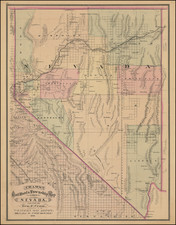
Early Territorial Nevada Mining Rarity
Rare early map of the Humboldt Mining District in by E.E.Fine, delineating the many mining districts in Humboldt County, Nevada.
The present map is one of only a few early maps to focus on the Humboldt County mining boom and among the rarest, this map having never previously appeared in a recorded dealer catalog or at auction.
The map provides one of the earliest depictions of Humboldt County, identifying a remarkable 29 separate "Mining Districts," and individually identifying the mines within each district (Sierra District having the greatest number, at 30). Within the mining regions, the center of activing is in the area of Humboldt City, Star City and Unionville.
In describing the map, Carl Wheat notes:
The map is finely detailed (no pun necessarily intended) in its presentation of the country from Pyramid Lakeon the west to approximately the 116th meridian. The Humboldt River is depicted from well above its junction with the Little Humboldt to Humboldt Lake, with teh complex mining development paralleling the River down both banks, especially in the Humboldt Range to the east. In extreme Northwest Nevada, "Queens River " is shown, with various minind districts beyond; near Pueblo City one legend says "Discovered June 1863."
Another legend, near Roops Trail, reads "Lassen's Grave May '59," with "Murder Rock" nearby. Only a "Pioneer House" marks eh site of Winnemucca as yet, but a Winnemucca Dist' and "Winnemucca Mts." are prominently seen off to the west. Along the Humboldt are the optimistic legends, "Humboldt Canal 63 miles long," and "Capable of Floating Timber from Pineries above."
In the north Paradise Valley (100,000 acres of Good Farming Land) is shown on the Little Humboldt River, east of the "Road to the Boise Mines Distance from Unionville N.T. 250 Miles).
To the southeast, the Road to Reese River is shown, another early mining region, with the road to Carson via Smith's Station shown above Humboldt Lake and the Road from Unionville to Dun Glen also shown.
The Truckee River and "New Truckee" are shown in pencil below Pyramid Lake. A road and proposed road to California are shown:
- Road from Honey Lake to Humboldt
- Road Nightingills proposed Road to California
Rarity
The map is exceedlingly rare. We were able to find any record of a public sale for the map.
We note only 3 surviving instutional (Hunington Library, British Library and the Bancroft Library).
Provenance: John S. Berry
![California [with large inset of Utah and Part of New Mexico]](https://storage.googleapis.com/raremaps/img/small/92004.jpg)