|
||

|

|
|

|
Stock# 59761
Description
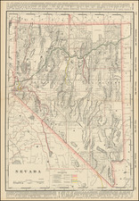
Rare early map of the Nevada Territory mining Districts.
The map receives nearly a full page write up in Wheat's Mapping of the Transmississippi West (#1129). Wheat identifies the source of the map as being from a pamphlet entitled The Mountain Queen Silver Mining Company . . . (New York, 1865), which is apparently known in only one example (New York Public Library). Wheat states:
. . . The main business of the map is to locate mining districts in Nevada; and a great many are shown. Special emphasis is given to Austin, since the Mountain Queen properties were half a mile south of the at city. In California, the only mining areas are noted (except "Sutter's Mill Coloma First Discovery of Gold") are "Cosmopolitan Copper Mine" at the head of the north fork of the Feather River, and some "Union and Table Mt. Copper Mines" north of the Calaveras River, between Sacramento and Stockton. The old emigrant road is shown around the north end of Great Salt Lake, down the Humboldt, and as far west as the Valley of the Mud Lakes east of Honey Lake. Railroads, actual or projected, are noted in the Sacramento Valley; and from Auburn the "Central Pacific Railroad" finds its way across the Sierra to the Truckee, thence over to and up the Humboldt, and on to Utah Lake by a route south of Snow Water Lake. . . . The "United States Mail Route," the old Simpson route, is heralded, "Proposed Railroad."
The map also seems to be one of the earliest printed map sources for a number of early Mining District names. See Joseph V. Tingley, Mining Districts of Nevada, Nevada Bureau of Mines and Geology Report 47 (1998). After De Groot's map, this seems to be one of the best early sources for locating the names of the earliest mining districts.
Condition Description
Folding map with cover page for pamphlet, folding into a self mailing folder.