


|
||

|

|
|

|
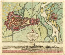
Detailed Manuscript Map Showing Area East of Dresden from War of the Sixth Coalition
Finely-executed and detailed manuscript map of Bischofswerda and its surrounding region, an area immediately east of Dresden. It was probably drawn just before or during the War of the Sixth Coalition, in 1813-14, and was likely drawn by a student engineer.
The map features Bischofswerda to the east and other settlements along the Wesenitz River and the area farther west. It is very detailed, showing woods, hills, valleys, and bodies of water. Settlements and their layouts are also shown in red. Roads are also marked clearly.
Bischofswerda as a town dates to the early thirteenth century. It was founded by the Bishops of Meissen and the city walls were erected in 1288. Authority for the town shifted from the Bishops in 1559 to Augustus, the Elector of Saxony.
Based on paleographic evidence, the map appears to date to the early-nineteenth century. It was likely drawn by a student engineer as a training exercise, based on the details included and the level of skill involved. It was possibly created as part of the War of the Sixth Coalition, one of several conflicts that made up the Napoleonic Wars. Also known as the War of Liberation in Germany, the war lasted from March 1813 to May 1814 and saw a coalition of Austria, Prussia, Russia, Britain, Portugal, Sweden, Spain, and several German states defeat the French army under Napoleon. Specifically, it most likely made before May 1813, when Bischofswerda burned.
In 1813, Napoleon led his army into the Germany principalities, determined to consolidate power there. A large battle took place at Lützen, near Leipzig and not far from Bischofswerda, on May 2, 1813. Next, they clashed farther west at the Battle of Bautzen on May 20-21. The French technically won both battles, but they lost nearly as many casualties, 40,000, as the Coalition, and their supply lines were longer and under intense pressure. Thus, the battles could be labeled Pyrrhic victories.
Just before the Battle of Bautzen, Napoleonic forces occupied Bischofswerda. The town had burned many times in the past, in 1429, 1469, 1528, 1583, 1596, 1641, and 1671. The fire of May 12, 1813 was worse than the previous blazes and the medieval town was completely destroyed. This is most likely one of the last maps drawn of the city before it burned.
On October 16-19, 1813, the armies met again at Leipzig in a fight that is now called the Battle of Nations. This time, the Coalition forces gave a Napoleon a decisive defeat. With 600,000 soldiers participating, it was the largest battle in Europe prior to World War I. Napoleon was forced to flee to France, which the Coalition invaded in 1814. Later that year, Napoleon had to abdicate and was exiled to the island of Elba.
After the War, Frederick Augustus I of Saxony ordered the town rebuilt on its medieval street plan. This map shows the town at a decisive moment in its history and in wider European history. It is a rare survival and a revealing historical object.
![(First state!) Tabula Europae IIII [German Empire & Baltic]](https://storage.googleapis.com/raremaps/img/small/95917.jpg)
![[Holy Roman Empire] A Newe Mape of Germany Newly Augmented by Iohn Speed Ano Dom: 1626](https://storage.googleapis.com/raremaps/img/small/67323.jpg)
![(Landscape Architecture) Der Thiergarten bei Berlin in Jahre 1840. Nach den Originalplanen des Konigl. Gartendirectors pp Hernn Lonne gez u lith v. G Koeber [The Thiergarten near Berlin in 1840. According to the original plans of the Royal Garden Directors...]](https://storage.googleapis.com/raremaps/img/small/89992.jpg)

![[ Holy Roman Empire, Poland, Baltic, etc. ] Germania VI Nova Tabula (First state!)](https://storage.googleapis.com/raremaps/img/small/94645.jpg)