|
||

|

|
|

|
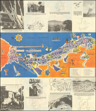
Finely executed map of the Ambatondrazaka District is a district in the Alaotra-Mangoro Region of Madagascar, centered on Lake Alaotra.
The map illustrates the area around Lac Alaotra, including the Lands of the Compagnie du Lac Alaotra.
The map is identical to a map of the same title in the Library of the Service Géographique de Madagascar.
The map identifies:
- Indigenous reserves
- Colonization Perimeters
- Land registered before the delimitation of the perimeters of colonization
- Location of the Company of La Alaotra
- Plot to distract colonization perimeters for the benefit of the natives (Proposals of the Director of the Domains)
- Itinerary followed by the Director of Domains
- Parcel of indigenous reserves to be incorporated into the perimeters of colonization
- Plot to distract colonization perimeters of the natives (Proposal of Mr. Administrator thistle)
The Compagnie du Lac Alaotra was formed in France at the end of the 19th century. Its business was Trade and livestock breeding in Madagascar, export in all countries, salted, frozen or preserved meat; any river transport company or maritime related to the purpose of the company; all farms, commercial, industrial or mining, construction and maintenance of all roads railways, trams, roads, canals, public or private works necessary or useful the purpose of the company and in general, all movable and immovable industry, banking, commerce, works that can be attached to society, by channel of contribution, merger or creation of new companies, or by any other means, in a word, all operations which may be connected with the object of society.
(Translated from Recueil des sociétés coloniales (1901) : Madagascar)
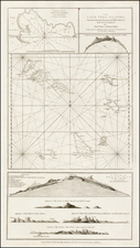
![(East Africa) Zanguebar [Zanzibar]](https://storage.googleapis.com/raremaps/img/small/98173.jpg)
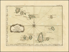
![[ Madeira ] Carte Des Isles De Madere Et Porto Santo](https://storage.googleapis.com/raremaps/img/small/101865.jpg)