|
||

|

|
|

|
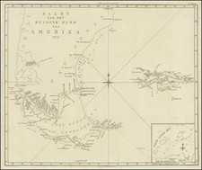
Portuguese Manuscript Map of Martín García Island, in Río de la Plata
Detailed manuscript map showing Martín García Island, at the entrance to the rich river basin near Buenos Aires. Today, the island is an Argentine-controlled nature reserve, but historically it was a strategic island that belonged to several powers.
This Portuguese language manuscript map shows the island with an eastern orientation. Several types of terrain are indicated by dots and other marks, while buildings near the port are drawn in plan. Rocks, marked with x’s, practically ring the island, included here as warnings to sailors. Various bays and inlets are labeled, with Atalaja at the center of the island. A banner proclaiming the subject of this sketch is strewn over the top edge of the map.
Martín García has been an important location for the imperial powers of the region ever since it was contacted by the Spanish in 1516. It is named for a storekeeper in Juan Díaz de Solís’ expedition who died en route and was buried on the island.
For the next two centuries, Portugal and Spain fought over the island, as it serves as the gateway to the Paraná and Uruguay Rivers. As this map is in Portuguese, it would suggest that this is a mid-eighteenth century sketch of the island, part of one of the Portuguese attempts to control the isle. However, the watermark of the paper is dated to the 1770s, after Spain had definitive control over the island, so it is more of a projection of Portuguese interest than an indication of possession.
Soon after this map was made, Martín García became a penal colony for the Spanish and later the Argentinians, who controlled the island from 1814. The island was a battlefield in the Argentine War of Independence and the Cisplantine War. In the 1840s, Uruguay and Argentina began to fight over the territory. Briefly, it was administered jointly by Argentina, Uruguay, and Paraguay, but then Argentina took sole control in 1886, making the island a naval base.
In the twentieth century, the island continued to act as a prison. Those interred here included German POWs in WWI and WWII, as well as Argentinian presidents including Hipólito Yrigoyen and Juan Perón. In 1973, the Treaty of Río de la Plata recognized Martín García as an Argentinian island surrounded by Uruguayan waters. It was also designated as a nature reserve.
Interestingly, thanks to a change in the stream flow between Martín García and its neighbor, the Uruguayan island of Timoteo Domínguez, have become fused. They represent the only land border between Uruguay and Argentina. This map, then, represents an island that no longer exists as it was drawn here, capturing a moment in history when its strategic value was high and empires fought for the right to possess it.
![Die Einwohner in Magellanica [The Inhabitants of Magellanica]](https://storage.googleapis.com/raremaps/img/small/94088.jpg)
![[Straits of Magellan] Carte Reduite Du Detroit De Magellan Dressee sur les Journaux des Navigateurs; Par le Sr. Bellin . . . 1753](https://storage.googleapis.com/raremaps/img/small/68956.jpg)
![Relacion del Viage, que por orden de Su Magestad, y acuerdo de el Real Consejo de Indias, hicieron los Capitanes Bartholome Garcia de Nodal, y Gonzalo de Nodal, Hermanos... Al Descubrimiento del Estrecho Nuevo de San Vicente, que Hoy es Nombrado de Maire, y Reconocimiento del de Magallanes [Bound with, as usual:] ECHEVELAR, Manuel de. J. M. Y J. Instruccion Exacta, y Util de las Derrotas, y Navegaciones, que se Executan en todos tiempos en la America Septentrional, de unos Puertos a otros: con las Advertencias de Sondas, y Notas, Para Ponerlas en Practica. Cadiz. 1753.](https://storage.googleapis.com/raremaps/img/small/89551.jpg)