


|
||

|

|
|

|
Stock# 59559
Description
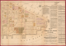
Hand-colored lithographed map of part of the Lower East Side, New York City, published by Spielmann & Brush in their very rare atlas Certified Copies of Original Maps of Property in New York City (1881). The last copy of that atlas was on the market with a New York City bookdealer for $12,500.
The map shows old lots and street names, and the area shown is bounded by modern-day Grand St., Clinton Street, Stanton Street.
![[ New York City Wall Map ] Map Showing the High and Low Water Mark and the Original City Grants of Lands Under Water Made to Various Parties from 1686 to 1873, extending from Battery to Fifty-first Street, Hudson and East Rivers, New York City Also The Several Pier and Bulk-Head Lines Established from 1750 to 1873. Made Under the Direction of the Department of Docks 1873](https://storage.googleapis.com/raremaps/img/small/96356.jpg)
![(Second World War -- Navy Day -- Aircraft Carriers) New York City Navy Day 1945 [Panorama of Manhattan's West Side from Across the Hudson]](https://storage.googleapis.com/raremaps/img/small/95396.jpg)