|
||

|

|
|

|
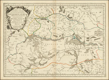
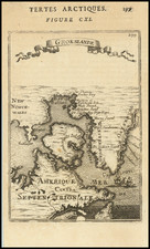
Finely executed map of the Northwestern part of America and Northeastern part of Asia, engraved by John Cary in 1781.
The map illustrates the limited English knowledge along the Northwest Coast of America and the Aleutian Islands, illustrating the discoveries of Captain James Cook.
The map highlights the limited knowledge of the region, which until recently had been influenced by the maps of Thomas Jefferys, Philippe Buache and the Robert de Vauguandy family of mapmakers, based upon the reports of the Russians and a mix of myth and legend developed by Guillaume De L'Isle and his successors, integrating the Bay of the West, River of the West and apocryphal accounts of the Northwest Passage.
Rarity
The map is very rare. We find no other examples, although the information at the top right margin suggests that it was Plate VII of Volume IV of a work we were not able to identify.
John Cary (1755-1835) was a British cartographer and publisher best known for his clean engraving and distinct style which influenced the entire map industry. Born in Wiltshire, John was apprenticed to an engraver in London. He started his own business by 1782 and moved to several premises before settling at 86 St James’s Street in 1820.
Cary had several significant collaborations during his career. John Wallis and Cary diversified Cary’s business to include broader publishing projects. Brother William and John made globes together, while brother Francis participated in the company’s engraving work. Finally, geologist William Smith and Cary developed and sold geological maps, some of the first of their kind. The pair also produced a notable series of county maps starting in 1819. Cary’s atlases, of English counties and the world, were the standard texts of the early nineteenth century. He was appointed surveyor of roads to the General Post Office in 1794, which led to the New Itinerary, first published in 1798.
John trained his son, George, in engraving and George and his other son, John Jr., took over the business in 1821. It was then known as G. and J. Cary and continued in trade until 1850. The firm’s materials were then acquired by George Frederick Cruchley and then Gall and Inglis. By the time John died in 1835, Cary was the authoritative name in private map publishing and his business was a leader in the field throughout the first half of the nineteenth century.