|
||

|

|
|

|
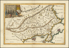
The Only Surviving Example of the Third State of this Lafreri Rarity.
A rare example of the late third state of this fantastic Lafreri School map, first issued prior to 1572 by an anonymous printer and here reprinted by Stefano Scolari in the 17th century. This map forms the southeastern sheet of a four-sheet map of Europe of which the southwestern sheet has never been found.
The map shows the Eastern Mediterranean in marvelous style. The map centers around Greece and the Aegean Islands, showing a blocky and elegantly elongated Hellenic Peninsula. Stretching out from land to sea between the Balkans and Candia (Crete), lakes, mountains, rivers, and hills dot the area. Further east is Anatolia and the Holy Land, with "Arabia Petra" covered in stones. Egypt contains a number of lakes and forests scattered throughout. The easternmost tip of Calabria and Sicily are visible, the latter labeled only "IA," a tantalizing sign of the southwestern sheet of the map, which is now unknown.
The decorative elements on this map are remarkable, with extravagantly large sailing ships and sea monsters. Off the coast of Cyprus, a "Vacca Marina" (sea cow) is shown, one of the rarer sea monsters to appear on maps. These sea cows are described in Medieval bestiaries including the 1491 Hortus Sanitatis, although depictions showing these creatures are uncommon on maps. One of the few other maps to include a sea cow as such is the fantastic Carta marina et descriptio septentrionalium terrarum ac mirabilium 9-sheet map of northwestern Europe published by Olaus Magnus.
The sources which were used in the making of this map are uncertain, with Bifolco and Ronca avoiding making any claims on the lineage of the map. However, Almagia suggests that the map is a derivative of the 1560 Gastaldi Geographia particolare d'una gran parte dell'Europa.
States
The map exists in three states. The second and third states are known only from the southeastern sheets. The states can be identified as follows:
- No editorial dating. Identifiable as pre-1572 from the Venician St. Mark's Lion appearing on Cyprus. Anonymous.
- In the lower margin, Valeggio formis imprint appears. Francesco Valeggio's period of activity was between 1598 and 1627.
- In the lower margin, the imprint Stefano Scolari formis in Venetia a S. zulian. Scolari's period of activity was between 1644 and 1687.
Rarity
This is the only known example of the third state of the map. The second state is known in one example of the southeastern sheet in a private Athenian collection. The first state is known in two examples, one example in three sheets (lacking the southwestern sheet) in Bergamo, and a second example in only the southeastern sheet in the Vatican Library.
The Lafreri School is a commonly used name for a group of mapmakers, engravers, and publishers who worked in Rome and Venice from ca. 1544 to 1585. The makers, who were loosely connected via business partnerships and collaborations, created maps that were then bound into composite atlases; the maps would be chosen based on the buyer or compiler’s interests. As the maps were initially published as separate-sheets, the style and size of maps included under the umbrella of the “School” differed widely. These differences can also be seen in the surviving Lafreri atlases, which have maps bound in with varying formats including as folded maps, maps with wide, trimmed, or added margins, smaller maps, etc.
The most famous mapmakers of the School included Giacomo Gastaldi and Paolo Forlani, among others. The School’s namesake, Antonio Lafreri, was a map and printseller. His 1572 catalog of his stock, entitled Indice Delle Tavole Moderne Di Geografia Della Maggior Parte Del Mondo, has a similar title to many of the composite atlases and thus his name became associated with the entire output of the larger group.
Sea Monsters on Medieval and Reneaissance Maps (Chet van Duzer)
Stefano Scolari was active between 1644 and 1687. He was a designer, engraver and editor from Brescia, although he practiced his trade in Venice. His shop, in S. Zulian under the sign of the Three Virtues, was one of the best known in seventeenth-century Venice. He engraved, printed, and traded in prints, particularly, maps. He specialized in the re-issue of important maps including Gastaldi's map of Lombardy and the 12-sheet map of Italy by Greuter.
![[Cyprus, Holy Land, Syria, Arabia] Tabula Asiae IIII (with) Tabula Asiae III on Verso [Armenia, Georgia etc.]](https://storage.googleapis.com/raremaps/img/small/88877.jpg)
![[Asilah, Morocco] Arzilla](https://storage.googleapis.com/raremaps/img/small/41197.jpg)