![Affrika třetj djl okrsslku zemského [Czech Language Edition] By Heinrich Bunting](https://storage.googleapis.com/raremaps/img/small/93470.jpg)


|
||

|

|
|

|
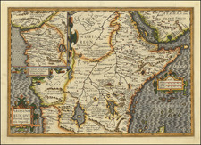
Exceedingly rare Czech language example of Bunting's map of Africa ( A frica Tertia Pars Terrae), which includes extensive contemporary manuscript notes within the map.
The map is based largely upon Sebastian Munster's map of Africa, first issued in 1540. Bunting presents the traditional Ptolemaic view of two lakes fed by the Montes Lunae (Mountains of the Moon) as the source of the Nile. However, Bunting's Africa differs from Munster's as he introduces a third large lake, Nidilis, shown in Central Africa above Elephantophagi, as a third source for the Nile. Several large cities and kingdoms are noted. The shape of the continent, presented by Bunting as tapering to a point at the Cape of Good Hope, makes this map unusual.
This scarce map is from Heinrich Bunting's Itinerarum Sacrae Scripturae, published in Prague by Daniel Adam z. Weleslawnja in the Czech language. It is believed that more than 60 editions of Bunting's Itinerarum were published in various languages between 1581 and 1757. Bunting's work describes the travels of religious figures in the Bible and was the most complete summary of geography of the Bible of this period. I tinerarum Sacrae Scripturae was first printed in Helmstadt in 1581 and was produced in numerous editions in Germany. The book was so popular, it was also issued with text in Danish, Swedish, Dutch, Czech, and English.
This example has been completely re-engraved and is a more attractive and stylized edition of the map than the earlier German edition. It is also slightly larger than the 1581 issue and the original Latin names are more legible. The publishers inserted metal type into the woodblock, which results in the different styles of lettering found on the map. Czech words have been added under the original Latin text, as well as a number of additional names in the Czech language, including place names, the names for North, South, East and West, and the title. The engraving for the sea is depicted as vertical waves in most examples; however the Czech edition features a fluid zigzagging of the oceans. A large sailing ship, a merman and an aquatic bird (possibly a swan) embellish the map.
According to Betz, this is a later woodcut map of Africa, whose appearance is rare and unusual, particularly in comparison to the availability of other maps from this period. Much of the paper used by Bunting was of inferior quality, which has left most surviving maps from I tinerarum Sacrae Scripturae in poor condition. Considering this, the present example is in very good condition. AMPR shows no examples of the map having been sold in the past 30 years with the Czech title.
Henrich Bunting was a Protestant theologian and teacher born in Hanover, in what is now Germany. He attended the University of Wittenberg and graduated in 1569. He then began work as a preacher but caused some controversy with his teachings; he was dismissed from appointments in both Lemgo and Goslar.
He is best known today for his book, Itinerarium Sacrae Scripturae (Travel book through Holy Scripture), a travel collection and commentary of the geography of the Bible. The book provided the most complete summary of biblical geography then available and described the Holy Land by following the travels of various notable people from the Old and New Testaments. First published in Madgeburg in 1581, Itinerarium Sacrae Scripturae was a very popular book for the time. Over 60 editions were published between 1581 and 1757.
A particularly notable feature of the book were its many woodcut maps, many of them showing unique depictions of geographic features and continents. In addition to the conventional maps, the book also contained three figurative maps; the world depicted using a cloverleaf design (thought to possibly represent the Trinity with Jerusalem in the center), Europe in the form of a crowned and robed woman, and Asia as the winged horse Pegasus.
![[Juba / South Sudan / White Nile] Sketch Map of Juba-Torit-Nimuli District](https://storage.googleapis.com/raremaps/img/small/92559.jpg)
![[ Africa. ] Tabula IIII. Aphricae. Hae Sunt E Cognitis Totius Orbis . . . (title on verso)](https://storage.googleapis.com/raremaps/img/small/103154.jpg)