|
||

|

|
|

|
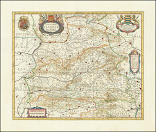
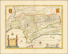
Decorative and highly detailed map of Southern Spain, extending from Salamanca and Segovia in the North, to the Gulfs of Valentia, Alicante and Cartgena in the east, the Straits of Gibralter in the South, and Portalegre, Alcantara and Merida in the west.
Shows Madrid, Sevilla, Cordoba, Granada, etc. Includes 4 coat of arms (Granada, Castilia Valentia, Murcia).
De Wit (1629 ca.-1706) was a mapmaker and mapseller who was born in Gouda but who worked and died in Amsterdam. He moved to the city in 1648, where he opened a printing operation under the name of The Three Crabs; later, he changed the name of his shop to The White Chart. From the 1660s onward, he published atlases with a variety of maps; he is best known for these atlases and his Dutch town maps. After Frederik’s death in 1706, his wife Maria ran the shop for four years before selling it. Their son, Franciscus, was a stockfish merchant and had no interest in the map shop. At the auction to liquidate the de Wit stock, most of the plates went to Pieter Mortier, whose firm eventually became Covens & Mortier, one of the biggest cartography houses of the eighteenth century.
![Utriusque Castiliae nova descriptio [New Description of Both Castiles]](https://storage.googleapis.com/raremaps/img/small/79695.jpg)