


|
||

|

|
|

|
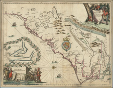
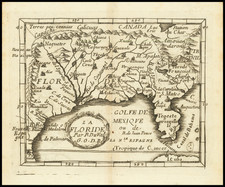
Rare regional map of Florida, the Gulf Coast and Southeastern United States, from Du Val's Le Monde Terrestre.
Du Val's map is based upon Sanson's 1657 map. The major difference is the prominence given the Rio del Spiritu Santu (Mississippi River), which pushed far west of its true location and course. Caroline is named at Port Royal, and the French claim to the Region is identified.
This is the third state, with the G.O.D.R. (Geographer to the King) status conferred upon Du Val and Nouvelle Espagne added at the bottom left corner.
While Du Val had previously used information by Lescarbot, this map uses the more up to date information contained in Sanson's map. A seminal map for collectors of the Gulf Coast, Florida and the Southeast.
Pierre Duval (1618-1683) was a French geographer, cartographer, and publisher who worked in Abbeville and Paris during the seventeenth century. He was born in the former city, in northeast France, before moving to Paris. Duval was the nephew of the famous cartographer Nicolas Sanson, from whom he learned the mapmaker's art and skills. Both men worked at the royal court, having followed the royal request for artists to relocate to Paris. In addition to numerous maps and atlases, Du Val's opus also includes geography texts. He held the title of geographe ordinaire du roi from 1650 and died in 1683, when his wife and daughters took over his business.
![[Rare First State] Novissima Tabula Regionis Ludovicianae Gallice dictae la Louisiane . . .](https://storage.googleapis.com/raremaps/img/small/72622.jpg)