


|
||

|

|
|

|
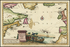
Striking chart of the Atlantic Ocean and surrounding coastal lands from Jansson's sea-atlas De Water-Weereld, or Atlantis Majoris Quinta Pars, Orbem Maritimum.
Jansson's Sea Atlas was the first of its kind intended for the general market, and then incorporated into his later publications. The chart covers the northern Atlantic Ocean with the eastern coast of North America, the West Indies, and the coasts of Europe and North Africa.
Cartographically Jansson's map is based on the previous maps produced by Hondius and Jansson, with a few notable improvements. The single Great Lake is replaced by a lake full of large islands and a complex system of waterways feeding the St. Lawrence River. There is a significant improvement in the delineation of the coastline between Chesapeake Bay and Long Island and in the north it shows Groenlandia separated by Meta Incognita. Penobscoi is named in present-day Maine for Penobscot Bay, and C. Cod is noted as well, in what becomes Massachusetts.
A nice example of this early sea chart of the North Atlantic.
Jan Janssonius (also known as Johann or Jan Jansson or Janszoon) (1588-1664) was a renowned geographer and publisher of the seventeenth century, when the Dutch dominated map publishing in Europe. Born in Arnhem, Jan was first exposed to the trade via his father, who was also a bookseller and publisher. In 1612, Jan married the daughter of Jodocus Hondius, who was also a prominent mapmaker and seller. Jonssonius’ first maps date from 1616.
In the 1630s, Janssonius worked with his brother-in-law, Henricus Hondius. Their most successful venture was to reissue the Mercator-Hondius atlas. Jodocus Hondius had acquired the plates to the Mercator atlas, first published in 1595, and added 36 additional maps. After Hondius died in 1612, Henricus took over publication; Janssonius joined the venture in 1633. Eventually, the atlas was renamed the Atlas Novus and then the Atlas Major, by which time it had expanded to eleven volumes. Janssonius is also well known for his volume of English county maps, published in 1646.
Janssonius died in Amsterdam in 1664. His son-in-law, Johannes van Waesbergen, took over his business. Eventually, many of Janssonius’ plates were sold to Gerard Valck and Pieter Schenk, who added their names and continued to reissue the maps.
![Amer. Sep. No. 19 & 20 [Partie du Groenland and Groenland Orientale]](https://storage.googleapis.com/raremaps/img/small/19107.jpg)