The item illustrated and described below is sold, but we
have another example in stock. To view the example which
is currently being offered for sale, click the
"View Details" button below.


|
||

|

|
|

|
Stock# 59307
Description
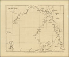
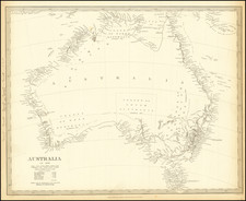
Large detailed map of Australia, showing bays, capes, creeks, islands, lakes, mountains, ports, rivers, shoals, towns, etc.
The Colony of South Australia is shown with its borders, established in 1834. Populations for New South Wales, Van Dieman's Land, Port Phillip, South Australia, West Australia and North Australia are shown. The interior is quite unknown.
An excellent early map of Australia.
![[ New South Wales Electors in 1871 ] Map Shewing Roads & Postal Stations in New South Wales Prepared for the Use of the Post Office Department](https://storage.googleapis.com/raremaps/img/small/88237.jpg)
![[ The Ptolemaic Universe ] Situs Terrae Circulis Coelestibus Circundatae . . .](https://storage.googleapis.com/raremaps/img/small/101512.jpg)
![[Heightened with Gold!] Paskaerte Zynde t'Oosterdeel Van Oost Indien, met alle de Eylanden daer ontrendt geleegen van C. Comorin tota aen Iapan](https://storage.googleapis.com/raremaps/img/small/83769.jpg)