


|
||

|

|
|

|
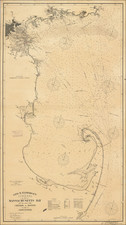
Exceptional Revolutionary War Era Chart of Massachusetts Bay.
One of the better charts from Des Barres' Atlantic Neptune, extending from Cape Ann in the north, through Boston, to Plymouth in the south, and showing Cape Cod from Wellfleet north.
This map chart would have been used by Revolutionary War-Era British captains and navigators in the pivotal Massachusetts theater. It was the best chart of the area available at the time.
This is an early state of the map, without the name "MASSACHUSETTS" in the interior. Des Barres charts are known in many variant states.
Joseph Frederick Wallet Des Barres (1721-1824) was born in either Paris or Basel, Switzerland, to a Hugueont family. He studied under the great mathematician Daniel Bernoulli at the University of Basel before immigrating to Britain, where he trained at the Royal Military College, Woolwich.
Upon the outbreak of hostilities with France in 1756, he joined the British Royal American Regiment as a military engineer. He came to the attention of General James Wolfe, who was impressed with his charting ability. During this period, he also worked with the legendary future explorer, James Cook, on a monumental chart of the St. Lawrence River.
Des Barres is best known for the Atlantic Neptune, was a remarkable, multi-volume set of sea charts and coastal views prepared from recent surveys, some of which were overseen by Des Barres in Nova Scotia after the Seven Years’ War. The maps, charts, and views were prepared under the supervision of Des Barres and employed as many as twenty engravers and assistants. They were produced over the course of a decade, from 1774 to 1784, in time to be used by the Royal Navy in the American Revolution.
After the Revolution, Loyalists were resettled throughout Canada. As part of this process, a new colony was created by separating Cape Breton from Nova Scotia. Des Barres, who already owned extensive lands in the Maritimes, served as lieutenant governor of Cape Breton Island from 1784 to 1787. He later served as governor of Prince Edward Island from 1804-1812.
Des Barres lived an exceptionally long life, even by today's standards, finally dying at age 102. Des Barres' funeral was held at St. George's Round Church in 1824 and he is buried in Halifax.

![[Harvard] Universita di Cambridge](https://storage.googleapis.com/raremaps/img/small/88045.jpg)